Tuesday, April 26, 2022

Petit Jean Mountain

Petit Jean State Park is Arkansas' oldest state park, and there is plenty of reasons to see why it has been preserved as a park since 1923. There are waterfalls, scenic trails, overlooks and unique Native American history. I made a visit there recently, just as the landscape was transitioning into the bright greens of Spring. This was the view from the Stout's Point overlook, near the supposed grave of Petit Jean herself.

IMG_7883

IMG_7899

I brought along the infrared camera, eager to use it now that the trees were getting leaves and vegetation was growing again. This was the view of the Arkansas River, as it rounds a bend near the base of Petit Jean Mountain.

P4170034

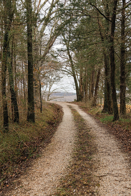
Nearby was this little dirt road that rambles off into the woods. I'm not sure where it leads (maybe to someone's house?), but I thought it might look neat with the infrared camera.

P4170046

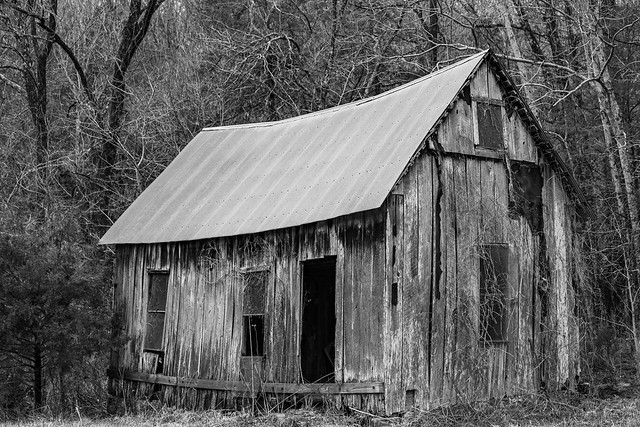
There is a lot of history at Petit Jean Mountain. Native Americans are thought to have lived here for many centuries (from around AD 900 to AD 1600). Their presence has been found in about 100 archeological sites on the mountain, including the largest collection of rock art in Arkansas. Settlers arrived at the mountain in the 1840s, and there is a pioneer cabin that still stands in the park from those early residents. By the 1900s, a lumber company acquired the land atop the mountain. Parts of their holdings were too rugged and difficult to log, but a worker for the lumber company thought "the idea occurred to me that the trees might as well be left to live out their lifespan unmolested by axe and saw, and the area converted into a park."

An idea was proposed to turn Petit Jean into a National Park, but the then-director of the NPS said that the lands were too small for consideration. Why don't you try for a state park instead? So the lumber company donated the lands to the state, which designated Petit Jean as Arkansas' first state park (there are now 52 state parks).

During the Great Depression of the 1930s, the Civilian Conservation Corps was established to provide work for unemployed men. A CCC camp was established on Petit Jean, which included many veterans from World War I. The CCC would build many trails and structures that are still in use today. One of those structures is the old water tower, which is shaped like a castle tower. There was a water tank in the upper level that provided drinking water to the nearby lodge and cabins.

P4170055

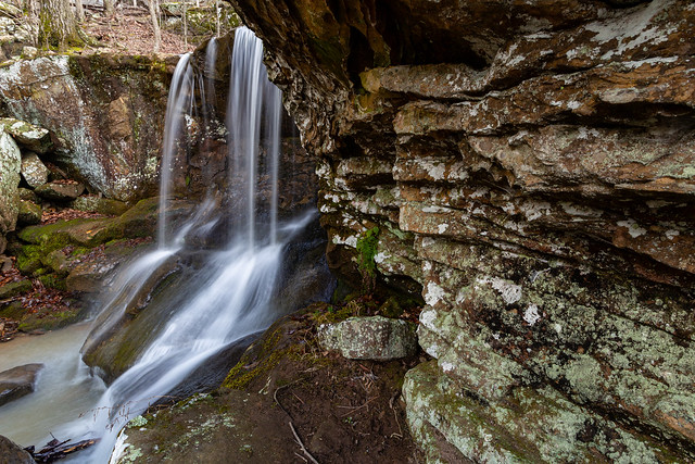
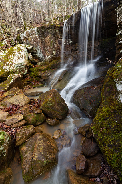
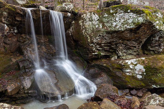
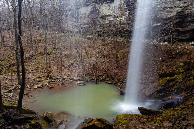
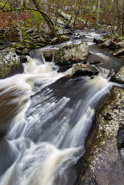
Another project of the CCC was the small stone dam that created Lake Roosevelt in 1935. The dam is a scenic little spot, especially with the small waterfall that flows over the rocks along Cedar Creek. A large tree sits by the waterfall, which had many new bright green leaves adorning it.

IMG_7926

Lake Roosevelt was named after President Roosevelt, who established the CCC. 

P4170073

IMG_7932

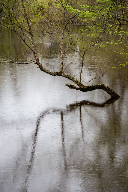
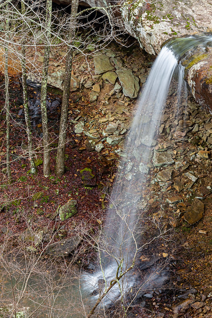
I didn't have enough time to hike to Cedar Falls on this visit, so I instead hiked along a short but scenic section of Cedar Creek.

IMG_7998-2

It had started raining while I was there, and I was thankful for the waterproof camera bag.

IMG_8002-2

This was taken from a wooden bridge that crosses Cedar Creek. It was a little worrisome, since a few of the boards were either rotten or were missing entirely. But obviously I made it across ok and survived the hike.

IMG_8007-2

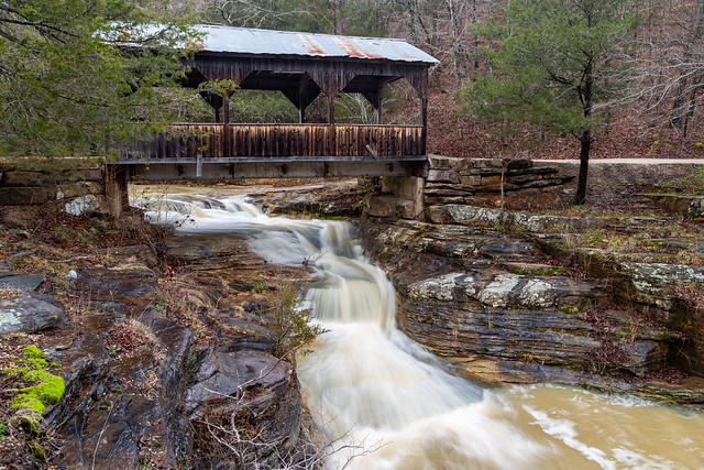
On the way back to the car I stopped to get this shot of the historic Davies Bridge, which was built by the CCC in 1934.

IMG_8016-Edit

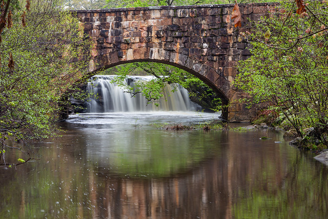
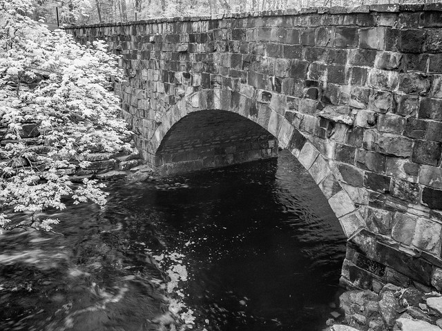
The Davies Bridge is just downstream from the waterfall on the Roosevelt Lake dam, and I tried to get a picture of the waterfall there with the infrared camera. This was the first time I tried getting a long-exposure on the infrared camera:

P4170115

And then a view of the bridge:

P4170120

And another view of the waterfall, this time in color:

IMG_8037-2

And a panoramic view of the waterfall over the dam, with the bridge downstream:

IMG_8046-Pano-2

After that it was time to head home, but I made one more stop at the Stout's Point Overlook. When I was there earlier, people were doing family portraits at the stone ruins that marked the spot of an old YMCA lodge that burned in the 1940s. When I went back no one was around, so I tried to get one last picture with the infrared camera before heading home:

P4170123

Wednesday, April 20, 2022

A Dark And Stormy Night

Last week a few storms passed through town. So I did what any rational person would do during a lightning storm, and went out with a metal tripod to try to take a few pictures. I headed over to Fort Roots, which sits on the "Big Rock" and provides this great view of downtown Little Rock. The approaching storm cloud was ominously stretching out across the sky over the city.

IMG_7673

IMG_7676

From there I headed across the river and went to the top of a parking deck that I hoped would provide a view of lightning flashing over some downtown buildings. But despite being up there for an hour and taking hundreds of pictures while storms passed by, I had no luck. I was pointing the camera in the wrong direction, so I moved the camera towards the east and managed to get a few bolts of lightning off in the distance.

IMG_7828

I checked the radar on my phone, and the storm that was producing the most lightning had moved way off in the distance (it had moved past the airport and was around Scott). I changed locations again and ended up at the Clinton Park Bridge, which provided this view of the distant storm and the Clinton Library.

IMG_7848

Thursday, April 14, 2022

Rattlesnake Ridge

If you have ever made the hike to the top of Pinnacle Mountain, you may have sat at the summit and looked at the views to the west. Reaching towards the horizon are several ridges. One of those is Rattlesnake Ridge, which is the rocky ridge seen on the far left view of this photo.

Pinnacle

Rattlesnake Ridge had sat on private land until 2018, until it was sold to the The Nature Conservancy of Arkansas. The land is now managed by the Arkansas Natural Heritage Commission, which oversees over 70 natural areas across the state. Rattlesnake Ridge, according to the ANHC, "protects rare plant and animal species, while offering visitors a rugged, low-impact recreational experience. The area provides habitat for three species of state conservation concern: the southeastern bat, the western diamondback rattlesnake, and Wright’s cliffbrake, a western desert fern. The ridge, Rattlesnake Ridge, is the watershed divide between the Big Maumelle and Little Maumelle rivers. It is comprised of a rare natural community, Ouachita Mountain Sandstone Outcrop Barrens, which is home to rare plants and animals typically found further west in hotter, drier places. The ridge, one of the most dramatic rocky summits in the eastern Ouachita Mountains, completes the northern boundary of the natural area. It is ¾ mile wide and rises up to 920 feet above sea level at its summit."

There are now several miles of hiking and biking trails at Rattlesnake Ridge. The hike along the ridge has been rated as moderate to difficult. But the views from the ridge were great, with expansive view of Pinnacle Mountain and Lake Maumelle. We didn't see any rattlesnakes while we were there, which was nice.

IMG_7651

Thursday, April 7, 2022

Back To The Buffalo

A few weeks back we headed up to the Buffalo River to do some camping over Jonah's Spring Break (his very first, as a kindergartner). And even with it storming and being cold, it seems like he had a good time. At least he had ready access to s'mores. We also camped with my Sister-In-Law and our three nephews, who I took hiking one day to Lost Valley.

Lost Valley is one of the most popular trails within the Buffalo River, and maybe even Arkansas. It's short, and incredibly scenic. We were there before the storms hit, so there wasn't much water in the creek. But there was enough for a bit of flow at the 53-foot tall Eden Falls.

IMG_7224

Later on we headed back into Boxley Valley, one of my favorite places in the state. It's an incredibly scenic and photogenic spot filled with many old barns and churches. One of those churches is the Beechwoods Church, which was built in 1918.

IMG_7233-2

The cemetery by the church is actually the oldest in the Valley, with graves dating back to 1842.

IMG_7236-4

This was taken the morning after some heavy storms dropped huge amounts of rain (which quickly extinguished our little campfire). The rain got the Buffalo River running high and muddy, and also left behind some big rain puddles. This puddle was by an old barn in Boxley Valley.

IMG_7329-6

The barn was built way back in the 1920s.

IMG_7336

Nearby is this old structure, which may have once been used as an old root cellar:

IMG_7342

It was fairly quiet in the Valley that morning, considering it was Spring Break. Which was nice since there wasn't too much traffic while I stopped constantly to take pictures of old barns:

IMG_7348-2

IMG_7355-3

IMG_7410-2

IMG_7441-2

This old building near the trailhead to Lost Valley may have once been used as a school:

IMG_7456

And down the road is another great old barn, which was built in 1915:

IMG_7464-4

While heading back to our campsite we passed through Ponca and stopped again at this covered bridge, where the creek below was running high after the storms.

IMG_7479-3

The big storms left behind plenty of rain to get waterfalls going, so my oldest nephew J.T. and my Brother-In-Law Casey decided to do the hike to Hideout Hollow to see the waterfall there. The hike was short and fairly easy. Unfortunately, it was a bit tricky to get down to the bottom of the falls. The only way there involved crossing the creek right above the 37-foot waterfall, and then making your way across a slick and narrow bluff to a spot where you can drop down. It seemed a little sketchy, so we just enjoyed the view of the falls from the top:

IMG_7495

There were a few small waterfalls along the creek above the falls, including this one that had an overhanging bluff with enough room to crawl back inside for a few pictures:

IMG_7508

After finishing that hike, we decided to hit another waterfall nearby - Sweden Creek Falls. The falls are located just outside of the Buffalo River boundary, but are protected by the Arkansas Natural History Commission. The trail to Sweden Creek falls runs downhill and then soon meets up with a small creek that has several neat smaller waterfalls.

IMG_7534

The waterfalls are along a smaller creek that runs into Sweden Creek. As far as I can tell, none of these waterfalls are named.

IMG_7541

But since the creek runs into Sweden Creek, I recommend that these falls be named either Norway or Finland Falls.

IMG_7548

I actually tried to do some research into who named this area Sweden Creek Falls. I didn't have much luck, so I'm guessing it was named by this guy:

via GIFER


But we made the short hike to the base of the falls, which are over 80-foot tall.

IMG_7553

The falls are scenic, but they are difficult to photograph. There are lots of trees around the base, so it's hard to get a clear view of the entire waterfall. And it also started pouring rain while we were there.

IMG_7560

IMG_7572

We hiked back to the car in the rain, and started to drive back to the campground. Along the way we passed by this old truck, which seems to have been parked here for quite awhile.

IMG_7580

I've gotten a few pictures of this old truck over the years, and not much has changed (besides some unfortunate vandalism). The first picture I have was taken 15 years ago - back in 2007:

Fixer-upper

We took the scenic route back to the campground and went through Boxley Valley again, and made one last stop to get a picture of the resident elk herd out in the fields.

IMG_7604-2