Sunday, December 31, 2023

Rhyolite and Vegas

After we crossed into Nevada, we were just a few miles from the ghost town of Rhyolite. After gold was discovered by the nearby Bullfrog Mountain, the town quickly sprung up in 1905. But by 1916, it was all but dead.

But at its peak, Rhyolite boasted a population of about 7,000 people. And it also featured "concrete sidewalks, electric lights, water mains, telephone and telegraph lines, daily and weekly newspapers, a monthly magazine, police and fire departments, a hospital, school, train station and railway depot, at least three banks, a stock exchange, an opera house, a public swimming pool and two formal church buildings."

IMG_0530

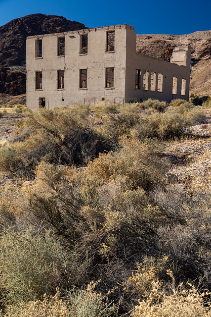
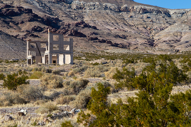
This was the former school building, which was built in 1909 and had room for 250 students. The school would close in 1911 after most families moved away after the gold mines began to decline.

IMG_0538

IMG_0540

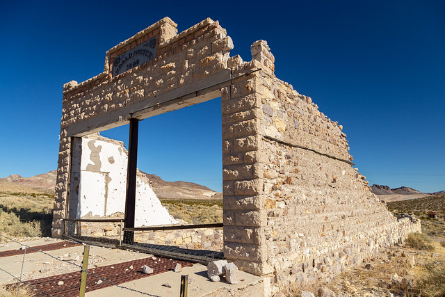
Nearby was the ruins of the old Porter Brothers' Store, which was built in 1906. According to the sign in front of the building, "it was the go-to destination for Christmas shopping. This was due in part to its amazing displays that rivaled those of the department stores in major cities. In fact, the store was the largest employer of people in Rhyolite aside from the mines. Unfortunately, even the popular store was not immune to the downturn that would decimate Ryholite's businesses; it closed in 1910."

IMG_0551

One of the most prominent buildings in Ryholite was the Cook Bank Building, which was built in 1908. The three-story building cost more that $90,000 to build (which would be about $2.9 million in today's dollars) and featured marble staircases and mahogany accents. But it was shortlived, the bank closed in 1910.

IMG_0566

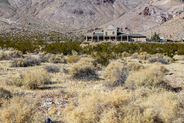
The best preserved building in Rhyolite is the train station, which was built in 1908 for the Las Vegas & Tonopah Railroad. But the station opened right at the time that the town began to decline, and within months of its completion the station saw more people leaving than it saw arriving.

IMG_0614

The railroad ceased operations in 1919, but the station got new life in the 1930s when it was used as a casino and brothel for a few years. In the 1960s, it opened as a museum and gift shop. It was empty on our visit, surrounded by a tall fence that made it hard to take pictures.

Untitled

Untitled

We followed the dusty dirt road to more remnants of Rhyolite's past. Here is what is called the "Miner's Cabin," although no one is sure what it was once used for. It was built around 1906, and due to its proximity to the railroad tracks and the old red-light district, it could have been used as a brothel or as offices for the railroad.

IMG_0651

Nearby were the ruins of the former jail, built in 1907. Shame that it's been marred by so much graffiti.

IMG_0690

From here was a good view looking back at the old bank building, and the tall mountains that surround it.

IMG_0668

And the old train station...

IMG_0721

Next to Rhyolite is the Goldwell Open Air Museum, an outdoor sculpture park and artist's workspace. The most prominent sculpture here is The Last Supper, which features life-size replicas of the figures from da Vinci's Last Supper. It was created in 1984 by Albert Szukalski, who draped plaster-soaked burlap over live models in order to create the ghostly figures.

IMG_0740

The same technique was used to create this piece, called Ghost Rider.

IMG_0733

And another large sculpture there was Lady Desert The Venus of Nevada by Dr. Hugo Heyrman, made out of cinderblocks.

IMG_0743

The sculpture collection was a good choice, I guess, to help us get acclimated back into the strange landscape of Las Vegas. We gassed up the car in the nearby town of Beatty and drove off.

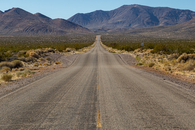
The drive back to Las Vegas is strange. There are lost of empty stretches of desert (and as they said in Casino: "A lot of holes in the desert, and a lot of problems are buried in those holes"). Then you see some random army bases in the distance. Was it Area 51? Perhaps, the alien-themed gas stations certainly suggest it might be. We could never tell for certain, since Area 51 doesn't show up on Google Maps for some reason. But then all of a sudden you hit city, and Las Vegas looms ahead of you.

We checked into our hotel, which was in the old downtown section of the city by the Freemont Street Experience. And it is an experience. And after days of quiet solitude in Death Valley, it was a culture shock. It was loud, crowded and busy.

Untitled

Untitled

Untitled

We walked around until we saw someone dancing on the street as a "naked Trump" waving a sign saying "Make America Sexy Again." That, and the fact that we had an early flight home the next day, meant that it was time to head back to the hotel for the night. There are some things that happen in Vegas that need to stay in Vegas.

Saturday, December 30, 2023

Death Valley - Time To Go :(

This was our last few hours left in the park. We would need to check out of the hotel, and then drive back to Las Vegas. But we tried to see as much as we could in the limited time we had. We drove up the turn-off to the trail to the Natural Bridge. We didn't have time to hike the trail, but took some pictures of the massive eroded mountains at the trailhead.

IMG_0426

The trailhead also had this view, looking back at the valley below. It really shows how large and vast the landscape here is. You can see the temporary lake that stretches across to Badwater Basin, the white saltpan, and the darker formations of the Devils Golfcourse. For a sense of scale, the lines that you can see at the bottom of the picture are roads.

IMG_0443

IMG_0472

After that we took the turn to the trailhead for Desolation Canyon. We didn't have time to hike the whole trail, but did walk along it for a few minutes to get a better look at these massive mountains.

IMG_0490

But now, sadly, it was time to check out of the hotel. We packed up our stuff and loaded the rental car up. It was windy that day, enough that it kicked up a lot of the dust and sand. In some places, it almost looked like a little sandstorm was going on.

IMG_0515

And then we reached the park boundary, and stopped to take one last picture. Like those lost 49ers, I looked back at the park and said "Goodbye, Death Valley." Then we headed across the border into Nevada.

IMG_0526

Friday, December 29, 2023

Death Valley - Artists Palette

Tucked off of the road to Badwater Basin in Death Valley is the aptly-named Artists Drive, which provides an up-close view to the tall mountains that line the valley.

IMG_0227

We stopped at the main overlook, called Artists Palette. The rocks here look like they were painted, in so many colors that it would make Bob Ross happy.

IMG_0263

IMG_0275

The colors are from ancient volcanic deposits, where oxidation and other chemical reactions produced various colors in the rocks

IMG_0280

The red, pink and yellow colors were caused by the oxidation of iron. The green was from the decomposition of tuff-derived mica. And the purple is from the oxidation of manganese.

IMG_0288

For a place filled with almost nothing but rocks and sand, Death Valley has so many different and varied landscapes. It's a really neat place.

IMG_0295

IMG_0299

We were there right after sunrise, while the mountains were still covered in shadow.

IMG_0305

IMG_0320

We got back on the Artists Drive road, which then headed up to an overlook of the Black Mountains.

IMG_0338

And then it passes through hills carved by erosion. Luckily there weren't many other people out that morning so we could make lots of stops on the one-way road.

IMG_0368

And then the drive ends with one last view of the vast saltflats of the valley.

IMG_0405

Thursday, December 28, 2023

Death Valley - Badwater Basin

Usually when we make trips out West and go hiking, I can blame me being worn out and tired on the elevation (instead of just being out of shape). But I didn't have that excuse this time, since a good portion of Death Valley sits below sea level. And one spot in Death Valley is the lowest spot in all of North America - Badwater Basin, which sits at an evaluation of -282 feet.

IMG_9997-2

The small pool of water here is what actually gave the basin its name. It is a spring-fed pool, and back in the olden days a surveyor led his mule here to get a drink. The mule refused, because the water was "bad." Turns out it's not poisonous, just really salty. There are some aquatic animals that live in the pool, including the Badwater snail, which is only found here in this valley. The plants along the pool are pickleweed.

IMG_0006

And another view of the pool, where the nearby mountains were reflected in the still waters.

IMG_0016

Badwater Basin was once a large inland lake that completely evaporated tens of thousands of years ago. When it was gone, it left behind concentrated deposits of salt. Now the saltflat stretches on for about 200 square miles. It's hard to tell in the pictures, but the place is massive.

IMG_0059-2

There usually isn't this much water here. This is all runoff from the hurricane that passed over the park a few months ago. Death Valley is a rocky place, with little to no vegetation. So all the rain that fell quickly ran down to the lowest point, where it has collected here. It won't absorb into the salt, so the water will remain until it's slowly evaporated away.

IMG_0082

Badwater Basin is the lowest place in North America, but not the world. That distinction belongs to the Dead Sea, which has an elevation of -1,358 feet below sea level.

IMG_0090

It had been bright and sunny all day, but some clouds appeared and helped to make a nice sunset that evening. The color in the sky reflected nicely in the waters of the ephemeral lake.

IMG_0133-3

And one last view of the lake, and the salt formations in the shallow water. The last light of the day is beginning the fade out in the distance.

IMG_0190

IMG_0208

Wednesday, December 27, 2023

Death Valley - Devils Golf Course

There are many odd and bizarre landscapes in Death Valley, but perhaps the strangest place in the entire park is the Devils Golf Course.

IMG_9923-2

The white stuff here, which looks like snow, is actually salt. The Devils Golf Course is a large saltpan, located at the bottom of Death Valley near Badwater Basin. About 150,000 years ago, this area was covered by an ancient lake, which had a depth of 30 feet. That lake evaporated entirely, but left behind a lot of dissolved minerals. Over time, the salt formations have been weathered and eroded into these jagged formations, which almost look like coral.

IMG_9924

The area gets its name from the National Park Service guidebook in 1934, which said that "only the devil could play golf" here.

IMG_9937

I'm sure some crazy people have probably tried to bring out some clubs and tried to hit a few golf balls from here. No doubt the NPS would surely frown upon that. But there is an actual golf course located not too far away by the Furnace Creek Visitor Center.

IMG_9938-2

IMG_9946

The golf course is massive, and stretches on across the horizon. You are free to hike across if it wish, but a sign advises to be careful since a fall onto the sharp formations would be painful.

IMG_9953

We survived without any falls, and took some last pictures before heading out to Badwater Basin...

IMG_9987