Wednesday, April 29, 2009

Downtown and the Baring Cross Bridge

After work last night I went out to try to find someplace to take a few pictures. I thought about heading out to the Big Dam Bridge, and then the Junction Bridge. Instead I finally ended up standing out next to yet another old bridge - the Baring Cross Bridge. Of the three old rail bridges crossing the Arkansas River at Little Rock, the Baring Cross is the only bridge that is actually still being used by trains (the other two - the Junction and the Rock Island, are either a pedestrian bridge or about to be converted to a pedestrian bridge).
P4284740
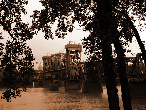
At the very left end of the bridge, you can see the dome of the Arkansas State Capitol poking out from the trees.

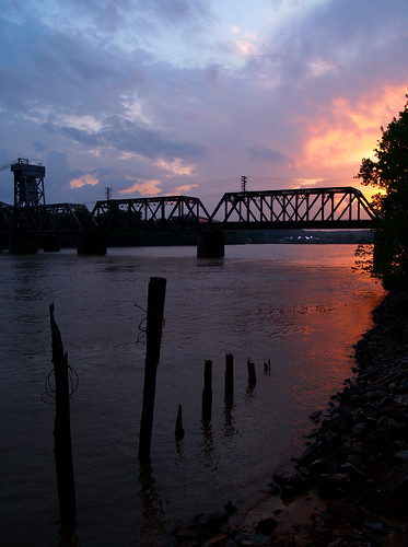
The weather people have said that is going to storm every day this week, but last night a bit of sunset peaked out from the clouds. From where I was standing, I couldn't really get a good view of the sunset. But this is what I got, looking through the beams of the Baring Cross Bridge.
P4284755

And a wider view, looking towards the west along the riverbank towards the bridge.
P4284765

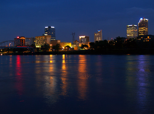
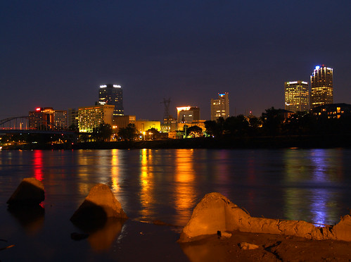
I originally went to this spot to get a shot of the Little Rock skyline. Not too far from the Baring Cross Bridge is an odd spot along the river, where some concrete pillars jut out into the water. I have no clue what these are here for, and there aren't any other similar concrete thingys like this along the riverfront. It could have been an old foundation for old electric lines across the river. My guess (probably wrong), is that this might have been a support for the first Baring Cross Bridge. According to the Encyclopedia of Arkansas, the original Baring Cross Bridge was opened in 1873, but was washed away during the great flood of 1927. The current Baring Cross Bridge was opened in 1929, and is operated by Union Pacific. It is still one of the busiest rail spans in the country.

So anyways, this is the view just downstream from the Baring Cross Bridge, looking across the river towards downtown Little Rock.
P4284801

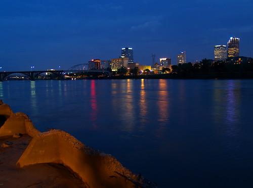
And one more view of downtown with the forgotten pieces of concrete stranded in the murky waters of the Arkansas River. The orange light on the concrete is from a nearby streetlight, which made it hard to frame the shot without it including my shadow.
P4284815

And finally, a shot of the skyline without any concrete foreground clutter:
P4284809

Tuesday, April 28, 2009

Little Rock Film Festival

One day last week, after work, I was pleased to find myself standing in the Clinton School of Public Service holding a beer. For one thing, it was cool to be drinking a beer in an actual school, which is also part of a Presidential Library. The other reason was to be a part of a reception for the Little Rock Film Festival while the schedule for this year's festival was announced.

I have a small part to play in this year's festival. Four of my pictures were chosen to be used as posters for the festival. All four pictures were taken at Petit Jean Mountain, and all have fog in them. Here are the posters, along with the pictures I took:
Photobucket
Road Trip

Photobucket
Foggy

Photobucket
Tree sandwich

Photobucket
Lake Bailey in the fog

I'm incredibly pleased and honored to have my picture's chosen as the posters for the festival. Already two of the posters have run as full-page ads in the Arkansas Times, and one will soon grace a billboard hanging up in town. The festival will feature over 70 films with over 140 screenings over five days. The festival will run from May 13th to the 17th. Check out their website for more info: http://littlerockfilmfestival.org/index.html

Thursday, April 23, 2009

Finding Nebo

The road leading up to Mt. Nebo just might be one of the steepest drives in the state. It features several hairpin turns as it switchbacks up the side of the mountain. Always a fun drive, especially when you're driving through thick fog. But suddenly the layer of fog ended, and the trip down the hill was in clear weather, with almost a bit of sun poking through the clouds. The trees along the drive were a vibrant and deep green, the color saturated from the rain. Unfortunately there aren't too many places along the steep road to get pictures.

At the base of the mountain I turned onto a side road that led past pastures and horse stables. Mt. Nebo loomed in the background, the upper reaches being hidden by fog.
P4184732

Further down the road was this field with a few horses. I wondered if the horses appreciated just how scenic their food plot was.
P4184736

I turned around and met the main road heading towards Dardanelle and Russellville. I quickly ran out onto the road to get a few quick shots of the road passing through this scenic valley before starting the big climb up Mt. Nebo.
P4184739
Those skid marks were already there - and weren't caused by some car trying to avoid some idiot photographer standing out in the road taking pictures...

Wednesday, April 22, 2009

On top of Mt. Nebo, all covered with fog...

The rain had pretty much stopped, and in its place came a thick fog. Just about the entire top of the mountain was covered, and is was difficult to see a few feet in front of you. From the waterfall, I drove around the mountain trying to seek out a few good pictures in the fog. I stopped by a small playground and walked around the woods a bit. A recently fallen pine tree jutted out into the mist, with this wave of needles diligently hanging on.
P4184700

Mt. Nebo has a lot of pine trees, and a lot of moss and lichen too.
P4184704

Mt. Nebo State Park has two great overlooks, each positioned to give great views of the sunrise and sunset. Those two points are, of course, called Sunrise Point and Sunset Point. I drove by Sunrise Point but it was completely walled in by the thick fog. But at Sunset Point, the fog was breaking up deep in the valley below. Fog and low clouds were drifting about the foothills below, with the trees a deep green.
P4184713

I drove on, passing through a camping area. There were wood chips scattered about in one area, which made a nice contrast with the distant fog.
P4184726

I walked deeper into the woods. One good feature at Mt. Nebo is the large amount of lichen-covered rocks that are seemingly everywhere at the park. This is the view including a rock that probably weighs twice as much as my car.
P4184729

Tuesday, April 21, 2009

Mt. Nebo Falls

Last Saturday was a slam dunk day for waterfall photography - if you didn't mind getting rained on. A few heavy storms were passing through, and I drove off in the rain trying to reach a waterfall or two. My original plan was to hit Pam's Grotto Falls in the Ozark National Forest. Along the way I decided to make a sidetrip at Mt. Nebo State Park, but it was so pretty there that I ended up staying there all day.

The state park sits at the top of the 1,350 foot tall Mt. Nebo. The mountain usually offers good views of Lake Dardanelle, rolling hills and even a nuclear power plant. But the top of the hill had a bit of a fog hanging over it, which would only get stronger as the day wore on. I drove around the park for a bit, standing in the rain and taking pictures. Finally I made it over to the waterfall, which seems to be a bit overlooked. I don't know why - it isn't listed in the Arkansas Waterfalls Guidebook, so many people probably don't know it's there. The falls probably only really run after very heavy rains, which worked out ok since it had been raining heavily all day.

About ten years ago I went out to these falls, way back when I was in college. I went with some friends who didn't seem all that interested in nature or waterfalls, and spent more time looking at a random old beer can that was laying along part of the trail to the falls. The can looked to be decades old, and we wondered the possibilities of how it ended up at this spot along the trail. When I got home on Saturday I talked to one of those old friends, and told him I had gone to the waterfall at Mt. Nebo. The first question he asked was - "did you see the old beer can?" I didn't see it, sadly.

The trail to the waterfall at Mt. Nebo starts out a parking area with a nice overlook. An old fence circles the parking area, which is slowly being covered in moss and lichen (along with a few trees).
P4184535

The trail to the falls is a short and easy hike (although a bit steep). The trail switchbacks down the hill, running alongside the creek that makes the falls. Along its run, the creek tumbles over several small waterfalls and cascades.
P4184537x

P4184548x

It was a really pretty area, and I spent a long time working my way down the hill.
P4184566

P4184578

I only saw two other people out on this trail while I was out there. They managed to hike in and out in the same time it took me to move about 20 feet down the creek. Taking pictures eats up a lot of time!
P4184586

This is looking down from the creek just above the main waterfall, you can see where it drops off below. Fog was swirling in, drifting over the hilltops in the distance. It was a great scene, which the pictures don't quite capture.
P4184595

The trail switchbacks further down the hill and then runs along the base of the falls. I'd guess that the falls are about 20 feet tall...
P4184605

And the view looking out from behind the falls, luckily there was plenty of room to set up the tripod without any spray coming back and hitting the camera.
P4184618

Looking up at Mt. Nebo Falls:
P4184639

And one last view, with a blooming tree in the foreground.
P4184673

I made my way back up the steep hill, stopping to get one last view of the creek that I missed on my way downhill:
P4184681

P4184691

When I got back to the car, a thick fog had settled over most of Mt. Nebo. I spent the rest of my time up there slowing driving through the thick fog, looking for more pictures...

Monday, April 20, 2009

Superman

The residents of Russellville, Arkansas, can sleep soundly at night knowing that Superman has moved there and is keeping watch over the city. I managed to spot Superman while driving down Hwy. 7. It seems as if Superman has set up shop in this old thrift store, where he keep a keen eye on the goings on there (I bet an ice fortress in Arkansas wouldn't quite work in the heat of summer).
P4184509
Someone should check in with the Russellville Courier to see if it has any articles written by a Clark Kent.

Of course all heroes need a sidekick, and it looks like Superman found one while staying in Russellville. Apparently, the blue M&M is always at hand, and is shown here giving a thumbs-up that says that the city is safe under their protection.
P4184510

Saturday, April 18, 2009

High Water at Petit Jean

So I was driving home on Easter Sunday and decided to make a quick side trip to Petit Jean Mountain. It had been pouring down rain all day (no doubt ruining thousands of Easter egg hunts), and there was water everywhere. I hurried to get up to the mountain before it got dark, eagerly thinking about all the water going through the many waterfalls at Petit Jean.

And man, were those waterfalls going - I don't think I'd ever seen more water flowing through Cedar Creek. Unfortunately, I didn't have time to hike the trail down to Cedar Falls before it got dark (looking back I should have at least tried, oh well), but I ended up being able to see a few waterfalls up there.

The first was the waterfall off of the small stone dam that forms Lake Bailey. I was both impressed and amazed to see the large volume of water flowing over the waterfall there. It was awesome.
P4124416

To compare and contrast, this is the same waterfall taken during my last trip to Petit Jean, in February:
Lake Bailey Falls

The wind was still blowing heavily, so most of the leaves on the trees have a bit of blur in them.
P4124434

And a view from the other side:
P4124456

And a view from about the same place, taken in January (I've made a lot of trips to Petit Jean so far this year):
A swirl at Petit Jean

And one last view of these neat falls, I'm still amazed at how much water there was going through.
P4124470

I hurried over to the other side of the old stone bridge and got another quick shot of the traditional place to get a shot of these falls - from underneath the span of the old 1930's bridge.
P4124478

And the same view, from January:
Under the Bridge

It was about 30 minutes before it started to get dark, so I hurried over to an overlook of the main waterfall at Petit Jean - the mighty Cedar Falls. Those falls are 95 feet tall, and were running full-tilt after all the rain. This is the view from an overlook, with some nice mist raising up over the falls.
P4124488

And one last comparison shot, this one taken in February:
Cedar Falls

And finally, a view looking down on the steep valley created by Cedar Creek. The trail to the falls is below, while the hillside is showing off its new spring greenery and blooming dogwoods:
P4124507

Thursday, April 16, 2009

The Scenic Route

From Flatside Pinnacle, I decided to take the scenic route over to Charleston while visiting the family over Easter weekend. This meant that instead of the freeway, I took Hwy. 10 west, which has a nice selection of stuff to take pictures of along the way. My first stop was at Lake Sylvia, a small lake in the Ouachita National Forest. Along the way, I stopped along the road and got this shot a blooming dogwood:
P4104370 copy

And another Orton-ized shot of the forest in its Spring colors, with an added bit of white from another blooming dogwood.
P4104375 copy

The recreation area at Lake Sylvia was closed for the season, but this was a view looking down the road from one of the closed-off parking areas.
P4104380

From there I got onto Hwy. 10 and headed west. I stopped at this old rail crossing in the small town of Perry (in Perry County, just down the road from Perryville).
P4104385 copybw

There were tracks that seemed to be the home of trains that looked like they hadn't moved in years. But there was a newish looking building, with a few cars parked outside, that was the home of a small railroad company. I was curious and did a google search of it, and found that it was the the home of the Little Rock and Western Railway, which is headquartered in Perry. The LRWN runs from Danville to Little Rock, and usually carries "wood and paper products, grain, limestone slurry, cornstarch, salt, LP gas, and pulp mill liquid." I've always liked trains, so its nice to see a small rail operation still up and running. This rail line was originally started in 1900, so its been around for awhile.

From there Hwy. 10 continues on towards the west, past more small towns. There were a lot of neat old buildings, but I didn't manage to get any good shots of them. Eventually, I took a random road off of Hwy. 10, which went through farmland and pastures. I stopped to turn around at this old barn:
P4104395 copybw

I might have been trespassing here, a dangerous thing to do since the Farm Bureau warns about doing anything bad out there. Luckily there was only a guard cow keeping watch on everything that day:
P4104398 copy

After that I again rejoined Hwy. 10 and headed farther west. I stopped again at an old barn, with Mt. Magazine looming in the background.
P4104400

After that I finally finished the trip by arriving in Charleston. But on Sunday I decided to take the long way back home again, taking the back roads and avoiding the freeway as much as I could. I stopped at this spot along Hwy. 64 between Altus and Clarksville for a shot.
P4124404

After that I did get back onto the freeway because I wanted to make a quick trip to Petit Jean Mountain, trying to seek out some waterfalls before it got dark...