Wednesday, November 30, 2016

Junction Bridge

While I was in downtown Little Rock last weekend, I headed over to the Junction Bridge to get a few pictures. The bridge is a popular connection over the Arkansas River, connecting the River Market on the south side to the Verizon Arena on the north side. The Junction Bridge was originally built in 1884. It was reconfigured in the 1970s so the bridge could handle larger barges passing underneath it. But the railroad would soon abandon the bridge. After sitting unused for several years, it was converted into a pedestrian bridge in 2008.

IMG_6409-4

The Junction Bridge actually sits right atop the actual little rock that gave the city of Little Rock its name. The rock was a small outcrop that jutted out from the riverbank, and is part of the foothills of the Ouachita Mountains. The rock got its name thanks to French explorers, who traveled up the river in 1722. After passing through the flat and meandering Delta, the explorers saw the small bluff and then a larger bluff upstream around a bend. They called the larger bluff The French Rock (or "le Rocher Francais" to be exact). It became known as Big Rock, while the smaller bluff became Little Rock.

IMG_6418-2

A town was eventually settled around the little rock, which quickly rose in prominence after it was chosen as the territorial capitol of the state (replacing the mosquito-infested and oft-flooded Arkansas Post). But as the new capitol city grew, steamboats began docking near the rock. As a result, the neighborhood around it became filled with saloons and brothels. Fights were routine in the area, so much that streets and alleys became known as "Battle Row" and "Fighting Alley." The neighborhood surrounding the rock was given the name "Hell's Half Acre."

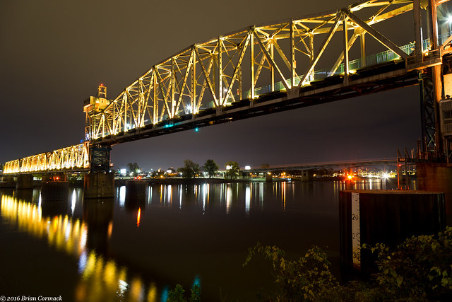
So it's almost easy to see why it would be allowed for the little rock to be mostly destroyed to make way for a bridge, since it wasn't in what was considered to be the best part of town. Starting in the 1870s, large sections of the little rock were dynamited away and then unceremoniously dumped in the river. The Junction Bridge actually used the remaining section of the rock as an anchor for the bridge supports.

IMG_6427-4

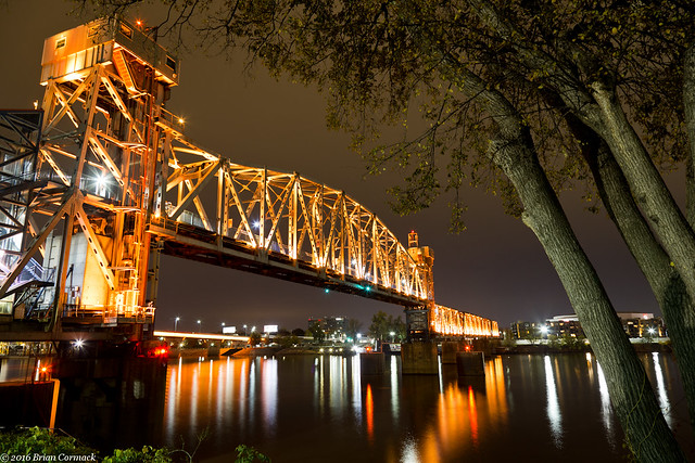
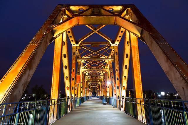
Of course nowadays it would be unthinkable to destroy a landmark like that, but I guess historic preservation wasn't the top priority in the 1870s. But the conversion of the Junction Bridge to a pedestrian bridge has become part of the massive revitalization that has taken hold of downtown Little Rock in the past twenty years. The bridge itself is a true attraction (and one of the best places to get pictures of the Little Rock skyline). The neighborhood around the old "Hell's Half Acre" is again seeing large crowds with people flocking to the River Market and the many restaurants and bars that line the streets (although there aren't any brothels around there nowadays).

Monday, November 28, 2016

Hickson Lake

After a bit of a delay, we finally managed to get some good fall colors here.  The trees in central Arkansas began changing in the middle of November (only a few weeks after their usual peak).  To take advantage of the change, I decided to head to Hickson Lake, in the Dagmar Wildlife Management Area. The WMA sits near the White River in the flat lands of the Arkansas Delta.

When we got there, I was a little disappointed to see that while the fall color was at its peak, many of the trees had already lost most of their leaves. I suspect that they were blown away when a storm blew through a few days before. Oh well. It's still a beautiful spot. the lake is lined with thousands of cypress and tupelo trees. So here's a shot of a little bit of fall color, reflected in the still waters of the lake.

IMG_6184-4

Tuesday, November 22, 2016

Buffalo River

The fall colors this year have been very strange.  October was warm and dry, so the trees decided to wait and postpone changing colors.  So around Halloween, when the fall colors are usually at their peak in the Ozarks, the trees were still mostly green or brown.

But while the fall colors weren't going to be the best this year, I made the 3 hour drive up to the Buffalo River a few weeks back. I left before dawn, sleepily driving through the dark towards Steele Creek. I arrived just before sunrise, and the river was quiet (except for some deer running around and some early-bird campers getting up). But I was amazed when I headed down to the river and found some good color in the trees growing right along the river.

IMG_5808-3

Maybe being by the water, the trees here had slightly cooler temperatures which caused them to change. The trees on the mountains above the river were mostly brown or had already lost their leaves.

IMG_5816-3

As the sun was rising, I drove over to Boxley Valley. This is one of the prettiest spots in Arkansas, a scenic valley filled with historic homes and barns. The valley's resident elk herd was out in the fields, along with the throng of people perched on the side of the road trying to see the elk. I hurried past and stopped to get pictures of this old barn, which was built in 1915.

IMG_5849-3

And one last shot, taken behind a barn in Boxley Valley. The mountain in the background was beginning to be lit by the light from the sun, as the rest of the valley woke up.

IMG_5872-2

Wednesday, November 16, 2016

Alley Mill, Missouri

After leaving Klepzig Mill, we drove over to the campground at Alley Mill and set up camp. Early the next morning, before sunrise, we got up and then headed over to Alley Mill. The mill sits right next to Alley Spring, and is considered to be one of the most photographed places in Missouri (the St. Louis Arch is probably the most photographed place in Missouri, but no one was keeping track when we were there).

It is a beautiful spot. The three story mill was built in 1894 and has a commanding presence next to the waters of the spring.

IMG_5283

Alley Spring has a daily discharge of 81 million gallons, making it the seventh largest spring in Missouri. The spring gushes out from the base of a bluff, where it rushes past the Mill and then eventually flows into the Jacks Fork River.

IMG_5306-4

IMG_5314-3

Another view of the Mill, which continued to operate until 1925. That year, the Mill and surrounding property became a State Park. In 1972, Alley Spring was acquired by the National Park Service and became part of the Ozark National Scenic Riverways.

IMG_5335-2

The sun was about to clear the hills, so we took a few more pictures before starting the long four hour drive back to Arkansas. This last shot is of the tall bluff that surrounds the deep blue waters of Alley Spring.

IMG_5341-2

Monday, November 14, 2016

Klepzig Mill, Missouri

From Blue Spring, we drove off to find another old mill.  After some more driving (things are fairly spread out in the Ozark National Scenic Riverways), we finally headed down the bumpy dirt road that runs by Klepzig Mill.  The mill was built in 1912 by Walter Klepzig, the son of a German immigrant.  According to the National Park Service website, Walter Klepzig was considered to be a "progressive thinker."  He was the "first in the neighborhood to introduce both barbed wire and woven fence wire and a refined breed of milk cow" (how is a cow refined?  Does it hold up its pinky when it drinks tea?).

IMG_5181-2

Klepzig also apparently "routinely saved 'good boards' for use in building coffins for his neighbors," which is an odd little note to mention on the NPS website. It was probably a well-intentioned thing to do in the rough and tumble Ozarks in the early 1900s, but it's also a little creepy. "Hey Steve, nice to see you! By the way, got some great wood for your coffin. Have a nice day!"

IMG_5190-2

The mill was certainly built in a very scenic location, overlooking Rocky Creek. The creek lives up to its name, as it is filled with huge boulders and waterfalls. This is the creek as it rushes under the mill.

IMG_5194-2

Klepzig Mill was used as a both a sawmill and as a mill to grind corn. In the 1940s, it was also used to help generate electricity.

IMG_5209-3

And one last shot of the mill, taken while sitting just above a waterfall that was probably about 15 feet tall. The mill overlooks a section of the creek that swirls and drops between huge rocks before calming down a bit past the mill. It was a very scenic spot that was one of our favorite stops on the trip.

IMG_5274-6

We made one more stop after this, and visited what is probably one of the most photographed places in Missouri...

Wednesday, November 9, 2016

Blue Spring, Missouri

From Turners Mill, we headed on towards Blue Spring.  Eventually after some more driving, we headed down the dirt road that runs downhill towards the Spring.

IMG_4997-2

After a short walk, we made it to Blue Spring. The Spring is aptly named, the water here is a deep and vivid shade of blue. The Osage called this the "Spring of the Summer Sky," which is pretty fitting.

IMG_5062-2

The color is due to suspended particles of limestone in the water, and also because of the depth of the Spring. Blue Spring is one of the deepest springs in the country, descending 310 feet. It's deep enough that if you were to walk the Statue of Liberty here all Ghostbusters 2 style and drop her into the spring, she would be completely submerged all the way past the torch.

IMG_5068-3

About 90 million gallons of water flow out from the Spring every day, making it the seventh largest spring in the Ozarks. From here the water creates a stream that then flows into the nearby Current River.

IMG_5076-2

Along the short hike back to the parking area, we walked by this side trail which snaked off into the woods. After that we headed back to the car and then drove on towards a few more springs (there are a bunch of them in this area!).

IMG_5111

Tuesday, November 8, 2016

Turners Mill, Missouri

From Big Spring, we headed over towards Turners Mill and Spring. The Spring is actually located in the Mark Twain National Forest, not very far from the Eleven Point River. Along the way, we drove down a few bumpy dirt roads. The fall colors were a little past peak there, but the trees still made for a pretty drive.

IMG_4764-2

IMG_4820-2

We drove to the parking area, and then made the short walk to Turners Mill. The mill is all but gone now, the only thing remaining is a huge 25 foot tall metal waterwheel. The wheel sits in the creek, as the clear waters from the nearby spring rush past.

IMG_4862-2

Although there is no trace of it now (besides the huge wheel), the mill here used to be four stories tall. From what I could find online, the mill dates back to the 1880s. The metal water wheel was added later, in 1915. The wheel (which must weigh tons) was shipped in pieces, with oxen bringing it to this spot along the creek. The mill supported the small town of Surprise, which is also gone now. The only building left is an old school that sits along a short trail not too far away.

IMG_4878-2

The mill used the waters of Turners Spring, which flows out from a bluff just upstream from the waterwheel. Around 1.5 million gallons of water flow out from the stream every day, flowing down hill and past the waterwheel before emptying into the Eleven Point River.

IMG_4897-2

We then walked back to the car and continued on towards a few more Springs...

Sunday, November 6, 2016

Big Spring, Missouri

One of the best photography trips I've ever been on was a short visit to southeast Missouri in 2012 with Zack Andrews. It was a spur-of-the-moment trip, and we headed up there without much planning. We left after work, and arrived at the Big Spring Campground at night. When we woke up early the next morning, we realized that we had somehow managed to get there right at the peak of fall color. We stayed the weekend, visiting some great spots around the Ozark National Scenic Riverways. It was amazing, and I knew that we had somehow lucked into getting there when the fall colors and the weather were perfect (if we had tried to plan it, we probably would have messed it up somehow).

I had some time off from work, so we decided to make a return visit to Missouri. There were a few spots up there that we missed during the last trip, so why not go back? I knew that we wouldn't be as lucky with the fall colors, but it is an amazingly beautiful area that is always worth visiting. So I packed up the car, and we again drove north into Missouri. And again, we got there late at night and were eager to see what the fall colors would be like in the morning.

We camped at Big Spring, which is one of the more popular campgrounds in the Ozark National Scenic Riverways. The ONSR is a part of the National Park Service, and protects parts of the Current and Jacks Fork Rivers. Just before sunrise, we headed over to the actual Big Spring, which as the name suggests is a huge and massive spring.

IMG_4543-2-2

IMG_4555-6

Big Springs is not only the largest spring in the Ozarks, it's also one of the largest freshwater springs in the world. Every day, an average of 276 million gallons of water pour out of a hole at the bottom of a bluff. The spring instantly creates a river, which flows a short distance into the Current River.

IMG_4570-6

The water at the spring is a bright shade of blue, thanks to suspended particles of limestone. In fact the rushing water is cutting through the limestone and creating a deep cave. Every day, up to 70 tons of dissolved limestone is carried away by the spring.

IMG_4577-3

Thanks to the constant stream of water, the rocks surrounding the spring are covered by a thick carpet of moss.

IMG_4593-3

The fall colors were a little past peak (our timing wasn't as great this time), but it was still well worth the four hour drive to Missouri. This is a spectacular spot and I took a bunch of pictures here.

IMG_4599-2

Near the Spring is this old cabin, so we made another stop and went to take a few more pictures.

IMG_4625-3

After taking a bunch of pictures, we decided it was time to move on and visit a few other places. This part of southeast Missouri is filled with springs. Unfortunately they aren't all close together so it takes a bit of driving to reach everything. But along the way, we passed a neat looking barn so we stopped the car and went to investigate.

IMG_4645-2

IMG_4654-2

And a heart-shaped hole on the weathered wooden door that sat along the dogtrot breezeway on the barn.

IMG_4663-2

And a small pine tree, growing by the side of the barn. The varying shades of color in the needles made an interesting contrast to the weathered gray of the barn wood.

IMG_4688-2

After that we continued driving on, heading towards another Spring. More pictures coming soon!