Tuesday, December 29, 2015

Capitol Christmas

Every December, the state switches on the 50,000 or so lights on the State Capitol and then has a fireworks show.  It's always a busy night, with hundreds of families crowding the lawn of the capitol.  This year was a bit different, the emcee of the night was 80s movie star Judge Reinhold.  But the kids in the audience seemed to be slightly more excited about seeing the Santa who made a brief appearance on the Capitol steps.  Also, a few of the adults around us didn't realize it was Judge Reinhold at first, they said they thought it was just a boring state judge going up to speak and tell corny jokes before the fireworks. 

The fireworks are set off directly behind the Capitol, and its a great place to take pictures (you just have to avoid the kids running around who like to bump into your tripod).

Capitolized

I headed back to the Capitol a few weeks later, on a rainy Sunday afternoon. The Capitol was open for people to come inside and see the holiday decorations, which include several large trees and even a place for Santa (who wasn't there, he was probably too worn out after trying to decide which state legislators were going to be on naughty list this year). This large Christmas tree sat in the rotunda, directly beneath the large crystal chandelier under the capitol dome.

IMG_1762-2

The Capitol is now over a century old. Construction on the capitol started in 1899 and was completed in 1915.

IMG_1887-2

The Capitol was actually built on the site of an old penitentiary. It's probably safe to say that the Capitol ended up being a much better use of the land than the jail.

IMG_2009-2

Monday, December 28, 2015

Big Dam Bridge

Before I moved across the river into Little Rock, I used to make a bunch of visits to the Big Dam Bridge. My old apartment was just a few miles away, and I would try to head over anytime it looked like there might be some neat fog or a cool sunset. But in the two years since I've moved, I've only made a few handful of trips back out to the bridge. So on a rainy and foggy night a few weeks ago, I drove over to have a look. It's now actually been nearly ten years since the Big Dam Bridge has been open, and it's still a popular spot for people to go walking or biking. Although there weren't that many people out in the rain the night this was taken.

IMG_1494

Sunday, December 27, 2015

Searcy

The oldest documented church building in the state of Arkansas sits just outside of Searcy. It's actually near where my In-laws live, so on a recent visit I headed over to the church. It was pouring down rain, which I hoped would look neat in pictures (it didn't, everything just really looked really wet). But it's a neat old church, constructed back in 1856 at the intersection of two wagon trails. The church has been recently renovated and is in great shape, considering its age.

IMG_1460

A few hours later we drove back through Searcy and went by the old White County Courthouse. The courthouse was built in 1871 and is believed to be the oldest functioning courthouse in the state.

I'm Dreaming Of A White (County) Christmas

It was pouring down rain when I took these, so please forgive me for one or two stray rain drops on the lens.

IMG_1473

IMG_1476

Wednesday, December 16, 2015

St. Louis

A few weeks ago we made a quick trip up to St. Louis.  Busch Stadium was hosting the first game of the US Soccer National Team’s World Cup Qualifying Campaign for the 2018 World Cup.  I’ve been to countless FC Dallas games, but never a National Team game, so we booked tickets before they all sold out and drove up to Missouri.  The US did manage to beat their opponent, St. Vincent and the Grenadines, with a score of 6-1.  I didn’t take my camera with me to the game, so I didn’t get any pictures of downtown St. Louis this time.

All the hotels downtown were either booked or were ridiculously expensive, so we ended up staying a few miles away near Forest Park. It’s a neat section of St. Louis – along with the large park there are many old historic buildings. The next day we stopped at one of them, the Saint Louis Art Museum. Located in Forest Park, the art museum sits in one of the only remaining buildings that was constructed for the 1904 World’s Fair. There is a lot of great art there (although it could definitely have more photography), including some places where it looks like the art is checking out the art.

IMG_0882

We then went to the Cathedral Basilica of Saint Louis, which was just a few miles away. The massive church was constructed between 1907 to 1914, although the interior took much longer to complete.

IMG_0930

Nearly every inch of space inside the cathedral is covered with mosaics. This is actually one the largest collection of mosaics in the world, containing 41.5 million pieces of glass in more than 7,000 colors, covering more than 83,000 square feet.

IMG_0991-2

IMG_0974

While construction on the cathedral ended in 1914, it took until 1988 to complete all of the mosaics.

IMG_0953

IMG_1005

After that we then went to the IKEA store in St. Louis, where we purchased a new dresser for the baby’s nursery. It’s been a few weeks since this trip, and I’m still slowly trying to figure out how to get the dresser assembled. The baby is due in two months, which will probably be about as long as it'll take to put it all together.

Thursday, December 10, 2015

Little Missouri Falls

From the Cossatot River, I headed east towards a few other waterfalls that are nestled in the Ouachita Mountains. I left the paved road, and headed into the Ouachita National Forest. There were some really good pockets of fall color here, the best I'd seen this season. This was near Shady Lake.

IMG_0630-2

The road began to run alongside this stream, which I think might be the North Fork of the Saline River. It was up and running high after some recent heavy rains in the area.

IMG_0663-2

The next stop was Bard Springs, which is the site of a small Forest Service recreation area. People used to believe that the waters of Bard Springs had medicinal qualities, and two small dams were built here during the Great Depression by the CCC, along with a bathhouse and picnic shelters.

IMG_0671-2

I've only been to this area once before, and I had forgotten how amazingly scenic it is. At one stretch, the dirt road heads up a steep hill while the creek below has carved a deep valley. The creek itself is crowded with boulders, and it looks like something that you'd find out West and not in Arkansas. I wanted to get a shot of it but couldn't find a good spot to stop. It's on the list for the next visit.

After driving down the bumpy dirt road I finally made it to Little Missouri Falls. This is a popular spot in the Ouachita National Forest, especially in the summer when its a busy swimming hole. The parking lot was full of cars, most of them from out of state (the majority of those having Texas plates).

The hike to the falls is short and paved, and there were some more good fall colors along the waterfall.

Little Missouri Falls

Like most waterfalls in the Ouachitas, the Little Missouri Falls isn't very tall. It's more of a series of cascades and stair-step waterfalls set inside a deep gorge.

IMG_0690-2

IMG_0707-2

From Little Missouri Falls I started to head home, but made one more stop at an old abandoned building in the small community of Hopper. Located near Caddo Gap, the old Hopper School was built in 1902. It's a large building, and it served several uses over its long life (including a community center, masonic lodge and a church).

IMG_0830

The building was abandoned in 1960, when a new church was built next to it. But even after sitting empty now for several decades, the old building is still holding on (although who knows how much longer it will last).

IMG_0844

Wednesday, December 9, 2015

Cossatot River

It isn't too often that we have both good fall colors and lots of running water at the same time. Usually things are pretty dry in the summer and fall in Arkansas, and most waterfalls are just barely running in October and November. But in the beginning of November, some heavy storms moved through and dumped a lot of rain. Which finally got the creeks back up and running again. The heaviest rain fell in the Ouachitas, so I woke up before dawn and headed out with the camera.

The original plan was to leave early enough so that I'd arrive at the Cossatot River at dawn. The hope was that there would be some cool fog or mist over the water. But of course, there wasn't anything when I got there. Luckily there was a lot of water flowing through the river to make up for it.

IMG_0392-4

The Cossatot River is about 90 miles long, and starts in the Ouachita Mountains near Mena. The most scenic and popular section of the river is protected as a state park. The name for the park is widely believed to be an old Native American word for "skull crusher," but it's actually French (cassĂ©-tĂȘte means "crushed head").

IMG_0428-3

The name probably comes from the rapids along the river, which are rated as Class IV and V. Some of rapids are amusingly named, such as the Whiplash, B.M.F., the Dishwasher and my favorite, the Cossatosser.

IMG_0451-3

This was taken at Cossatot Falls, which is really more of a long series of tall cascades. The river drops and churns past boulders and rocks that have been shaped and sculpted by the rushing water.

IMG_0493-5

IMG_0576-3

IMG_0548-2

A light rain started to fall, and I took a few more pictures before driving out to visit a few more waterfalls

IMG_0583-3

Tuesday, December 8, 2015

Buffalo River

The weekend after we returned from our trip to Arizona, I headed up into the Ozarks to try to catch some pictures of this year's fall colors. The drought we had this summer seems to have zapped a lot of the color (the oaks mostly just turned brown), but you could still find places with great fall colors in the Ozarks and Ouachitas.

I left early in the morning, and encountered some thick fog as I got higher into the Ozarks.

Someone left the fog machine going

The fog was really thick, and luckily there wasn't much traffic out that morning. I did find a safe place to pull over to get this shot of an old abandoned home that was nearly shrouded in fog.

This Old House

I drove out of the fog when I descended into Boxley Valley, along the Buffalo National River. This is one of the most scenic places in the state, and I was interested in seeing it with some fall color. The first stop was the parking lot at Lost Valley, where I was to meet up with my Aunt (another photographer, who was driving down from Berryville). I walked around the Lost Valley area for a few minutes, stopping at a few places. This old building was apparently an old school, but I couldn't find any info on how old it is.

IMG_9832

After we met up with each other, we stopped at a few more places near Lost Valley. This is along the creek-bed for Clark Creek, which flows out of Lost Valley. It was completely dry, which wasn't surprising since the creek usually runs underground through here (unless there has been a lot of recent rain, which we hadn't had in awhile). Instead of water, the creek was filled with thousands of fallen leaves.

Lost Valley

And we went by a few other places that had some great displays of fall color. It's a shame the trees are only this colorful a few weeks out of the year.

IMG_9949

Our next stop was the old Boxley Mill. The first mill in Boxley Valley was built in 1840, near a small spring. The mill was even the location of a minor Civil War skirmish (called the "Battle of Whiteley's Mill"). After the war, the original mill was replaced with the current mill in 1870.

IMG_0062

The mill continued to operate until the 1960s, until it finally closed.

IMG_0076-3

IMG_0043-2

All of the original mill equipment is still inside the old building. It actually looks fairly close to what it must have looked like back in the olden days (besides the interpretive signs installed by the Park Service). The Park Service actually opens the mill up every once in awhile, including the day that we visited. This is the view looking out through one of the old windows.

IMG_0019

Nearby is this old springhouse, which is right by the road but is well hidden by trees and vegetation.

IMG_0100

We then drove by the huge crowd of people parked along the side of the road trying to see Boxley Valley's resident elk population. Elk were native to the Buffalo River area, but all of the elk were hunted and disappeared in the 1800s. But several elk were reintroduced, and have since flourished in Boxley Valley. Now they are one of the most popular attractions here, with people lined up along the road to view the elk. We stopped to take a look, joining a few other photographers with zoom lenses that probably cost more than my car.

IMG_0143

After that we drove out of Boxley Valley and visited the Steel Creek access along the Buffalo River. This is another one of the most scenic places in the state, where the Buffalo travels under some tall bluffs. This is the view of Steel Creek, near its confluence with the Buffalo River.

IMG_0268

We then headed over to the campground, and then hiked along the edge of the river. It's a beautiful spot, where the river curves around Roark Bluff, which towers 200 feet above the river.

Roark Bluff

From there we headed over to Jasper, and had a late lunch at the Ozark Cafe. After that it was time to head home, so I started the drive south towards Little Rock. Along the way, I drove into another band of thick fog. And again, I found a good place to pull over and tried to take a few pictures. It was getting dark, but I got a few pictures of a field that was enveloped by fog before I hit the freeway and made it back home.

IMG_0345-2

IMG_0367-2

Monday, November 30, 2015

Monument Valley & Canyon de Chelly

After we finished our Antelope Canyon tours, it was time to check out of the hotel and start heading back home to Arkansas  (only 1,270 miles away!).  It would be a long drive, but there were a few iconic places that we would be passing by along the way.  After a few hours of driving, we took a small detour and headed north into Utah and visited Monument Valley.  Located on Navajo tribal land, Monument Valley is the famous collection of sandstone buttes that have been featured in countless films and been the subject of millions of pictures.


IMG_9619-2

Once you look past the crowded parking lot and the RVs, it’s easy to feel like you’re on the set of a Western movie. John Wayne could easily trot by on a horse. I admit to doing some photoshop here to get rid of the graffiti on the rocks in the foreground, which were carved there by some idiots.

Monument Valley

We headed out and trekked across Arizona, driving southeast. A few hours later, we drove by Canyon de Chelly National Monument, and made another short detour to visit the park. Canyon de Chelly is also part of the Navajo Nation, and a guide is required if you journey into the canyon. But there are a series of overlooks along the rim of the canyon that can be visited without a fee or guide. It was close to sunset, so we just barely had time to drive to the Spider Rock overlook before dark. This overlook provides a grand view of the Spider Rock, a tall 750 foot sandstone spire that rises from the canyon floor. Traditional Navajo belief is that the rock is home to the Spider Grandmother, the creator of the world.

IMG_9687-3

We left the park as it was getting dark and continued on, eventually reaching our stop for the night in New Mexico. Early the next day we got up and drove all the way back home to Little Rock. It was a long day of driving, but we listened to the audio book of Ready Player One which really helped pass the time. That night, we finally arrived at the house, after driving a grand total of 3200.4 miles over the course of nine days. After unpacking, I started to look through all the pictures and then wished I could take another week off from work so I could work on them all.

Sunday, November 29, 2015

Lower Antelope Canyon

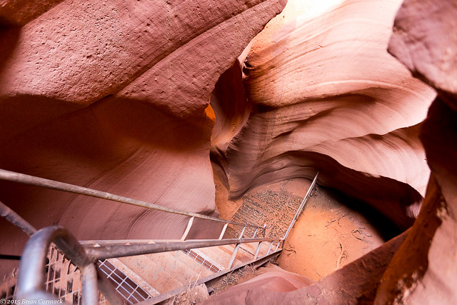
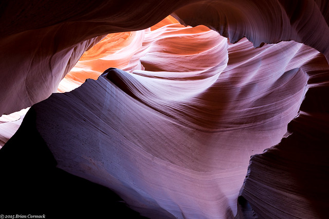
One place that we really wanted to visit while in Arizona was Antelope Canyon - the very popular slot canyon that you've probably seen before in either countless photographs or that one Britney Spears video. It's one of the most photographed places in the West, and with good reason. The inside of the canyon is stunning. It is also over-crowded and a true pain to take pictures in. But earlier this year, a photographer sold a print from Antelope Canyon for an obscene amount of money, so I'm waiting for someone to spend a few million on these photos!

To tour Antelope Canyon you have to book a tour with one of several tour groups that operate with the Navajo Nation (the canyon is on Navajo land, and each tour must be accompanied by a Navajo guide). As soon as we had the date for our trip picked out, I called to book our tour. Now you can do two different tours, a regular tour and a photographer's tour. The photographer's tour is longer and you can use a tripod. But by the time I called, all of the photo tours had long been booked.

Then I realized that there is actually two Antelope Canyons, an Upper and a Lower. The Upper is the more popular section of the canyon since it is easier to walk around in. The Lower Canyon has some steep ladders and it can be more narrow. But there were some openings still for the Lower Canyon photo tours, so I quickly booked one. The ladders and narrow walls were too much for a pregnant person, so Caroline did the Upper Canyon instead (which she says was incredible).

But we almost didn't get to do the tour. Some heavy rains led to some flash flooding in the Canyon, and it was closed for several days. My original tour was cancelled, but luckily they would open up the next day. Since we were about to leave Page and drive home, we just barely had enough time to squeeze in our tours. So early the next morning, we both left to visit the Canyon. The entrance to the Lower Canyon is indeed steep, with several tall ladders heading deep below ground.

IMG_9125-2

There were only two other people on the photographer's tour, and we were led by a Navajo guide. The guide would point out different spots to take pictures, and then stood around watching as we tried to take pictures. If any other tour groups would come through she would escort them around us and even chastise them for using the flash on their cameras.

IMG_9111-2

IMG_9138-2

While there were only two other photographers on the tour, it was impossible to keep from getting in each others way. One of the photographers would stick her tripod right in the middle of a room, and would stay there the entire time we were there. And it seemed like just as soon as I got a shot set up, the other photographer would stroll up and then stand right where I was trying to take pictures. I'm sure I also messed up a bunch of their shots. The canyon is narrow and there isn't much room to move around.

IMG_9166-3

IMG_9173-2

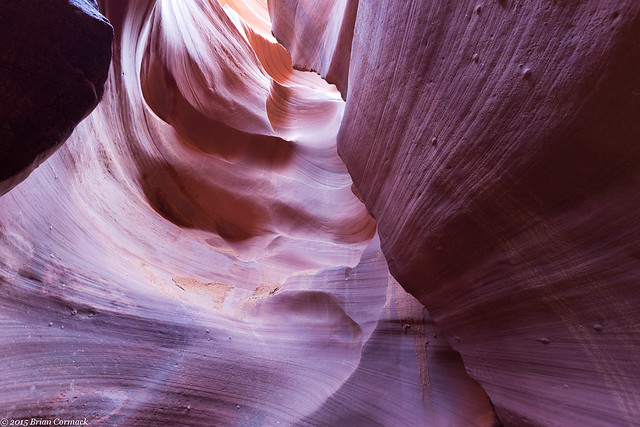
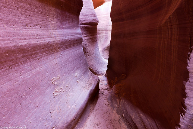
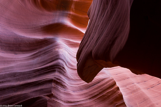
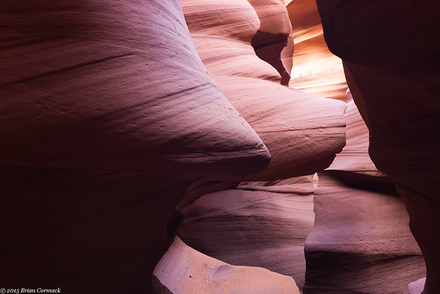
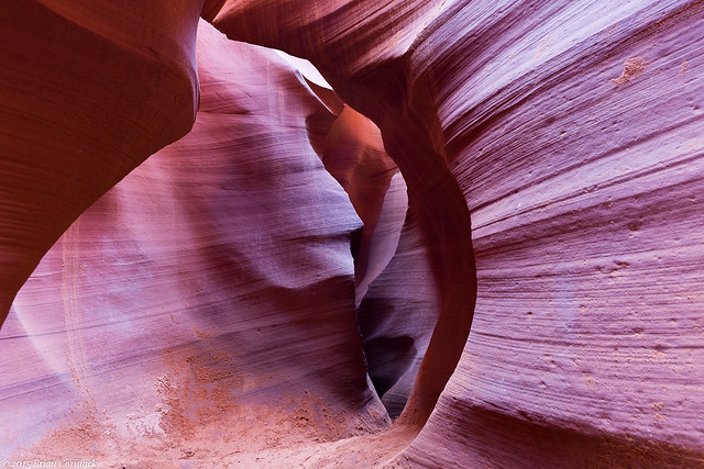
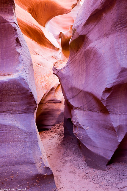
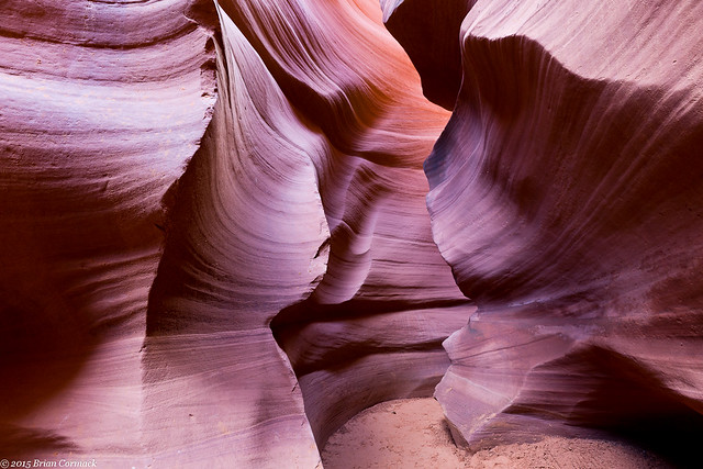
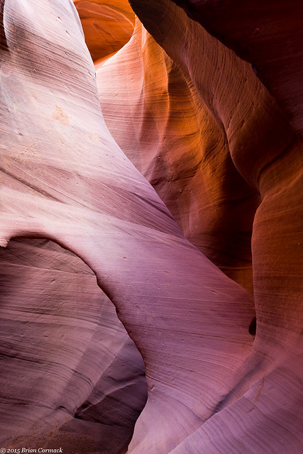
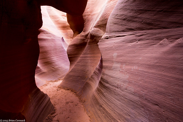
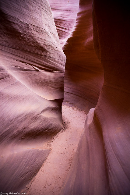
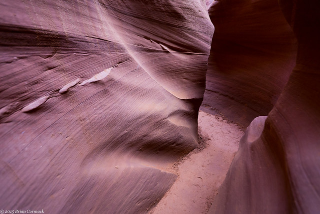
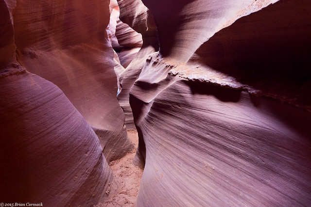
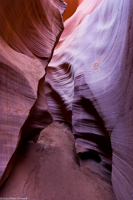
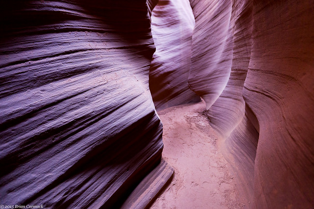
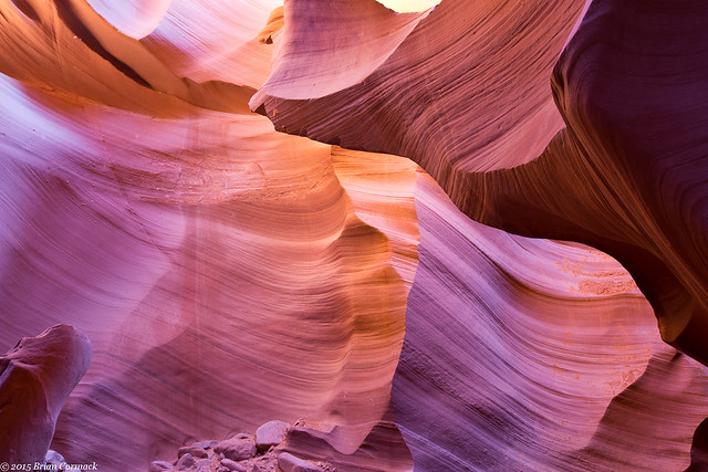
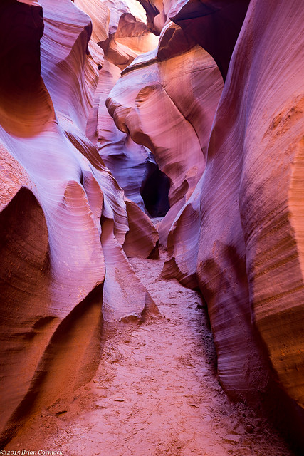
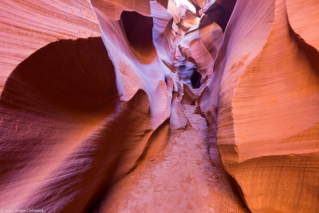
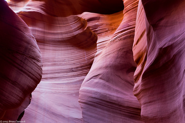
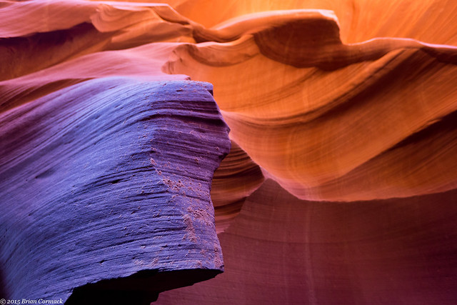
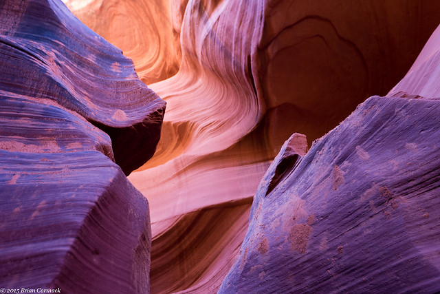
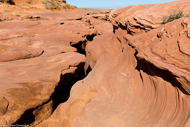
The Lower Antelope Canyon is called HazdistazĂ­ by the Navajo, which means "sprial rock arches." The canyon was formed by erosion, with flash floods over eons carving out the canyon and creating the soft flowing curves on the walls.

Lower Antelope Canyon

IMG_9192-2

My tour guide said that after the flooding earlier, the water in the Canyon was about waist-deep and it took awhile it to dry out enough to get everything cleaned up.

IMG_9211-3

IMG_9229-2

IMG_9237-2

IMG_9239-2

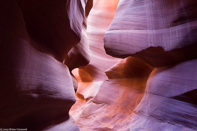
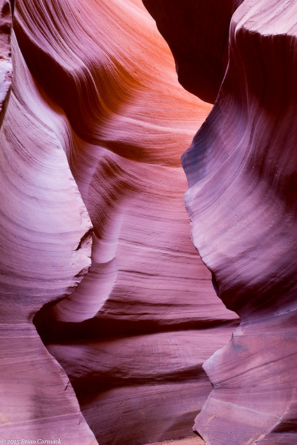
There are a lot of shapes and curves that have been carved into the rock. Here the canyon created a delicate arch. I tried to get a good picture of the entire archway but one of the other photographers came in and put her tripod right at the bottom of it. So I zoomed in to crop her out and got this shot instead.

IMG_9251-2

At one point the canyon got so narrow that there wasn't room to set up a tripod, and you'd hope that no one would try to walk by when you're taking a picture.

IMG_9259-2

IMG_9267

IMG_9271

IMG_9351-2

I'm not entirely sure that the two other photographers on the tour spoke English, so the guide had a hard time communicating with them. We only had two hours in the canyon, and we had eaten up a lot of that time. But one of the other photographers was taking so long that we eventually left her, with the guide occasionally backtracking to make sure she was ok.

IMG_9364-2

IMG_9413-2

IMG_9427-2

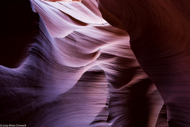
Antelope Canyon is famous for the beams of light that shine through the canyon, but we weren't there at the right time for that. The beams appear in the summer, when the sun is highest in the sky. But it's kinda good that we were there at the wrong time because the crowds weren't as bad.

IMG_9441-2

IMG_9453-2

IMG_9459-2

Time went by really quickly, and we were soon nearly at the end of the tour.

IMG_9470-2

IMG_9542-2

IMG_9582-2

And then we reached the end, and headed up some stairs and through a narrow crack in the rock to exit the canyon. This is the spot where you climb out, with the guides saying "Watch your head" over and over.

IMG_9596-2

After that we packed up our stuff and checked out of the hotel, and started the long drive back to Arkansas. But there were a few more places that we were planning on seeing along the way...