Thursday, December 29, 2016

Big Dam Bridge

My In-laws were kind enough to give me a new tripod for Christmas, so I was excited to head out the other night to try it out.  I went out to the Big Dam Bridge, the nearly mile long pedestrian bridge over the Arkansas River that just celebrated its tenth birthday in September.

IMG_7236-3

It had been raining all day, and a little bit of fog was drifting along the river. I tried to maneuver the tripod legs around (probably should read the instructions sometime), to get this shot of a puddle that formed in the pavement. Luckily I was able to get a few shots there without managing to drop the camera and new tripod into the river.

IMG_7251-3

Tuesday, December 27, 2016

White County

While we were in Searcy over the weekend for Christmas with my In-Laws, Jonah got a little fussy and refused to go take a nap. So I used the classic last resort of driving him around for a bit until he fell asleep. While driving the back roads of White County, I passed by this old truck rusting away next to some tall trees. I quickly took a picture while the baby snoozed away in the backseat.

IMG_7177-4

Thursday, December 22, 2016

Downtown

I headed out after work to try to get a few pictures in downtown Little Rock.  It was cloudy, with an occasional raindrop falling down and trying to land on the lens.  My first stop was the State Capitol, which had just had the holiday lights switched on.  It's a pretty light display, although I do miss the days when the lights on the dome spun around (the "Disco Dome").

Under The Dome

After that I made a quick visit to the Junction Bridge. Here's one last shot, taken with the fisheye lens that I had borrowed for the visit to the old Saenger Theater.

IMG_6786-2

Friday, December 9, 2016

Saenger Theater

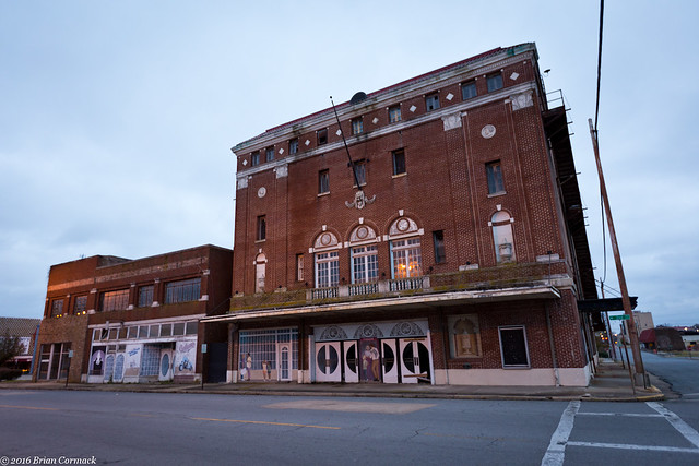
I was lucky to be given another opportunity to go inside the old Saenger Theater in Pine Bluff, this time with a friend and fellow photographer Bryce. The Saenger is an amazing place, a once grand and ornate theater that has sadly been left abandoned for several years.

IMG_6436-2

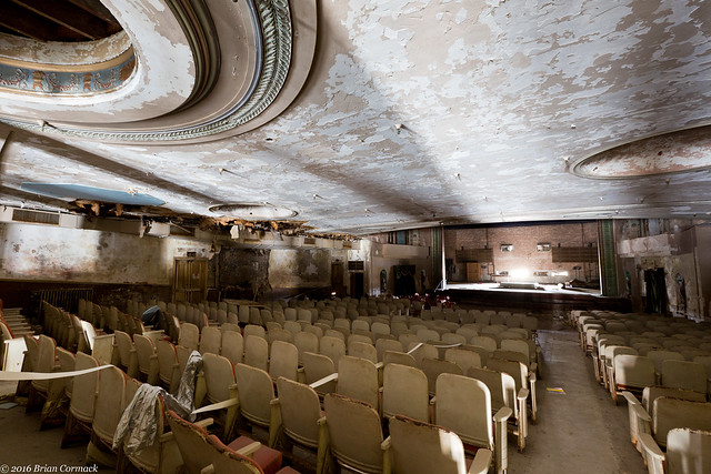
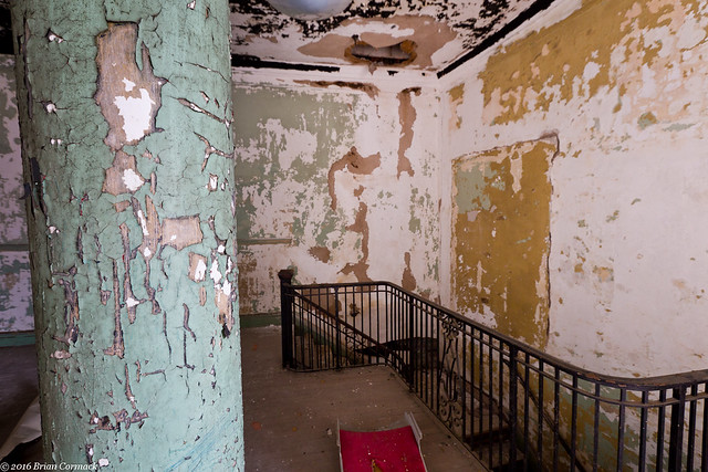
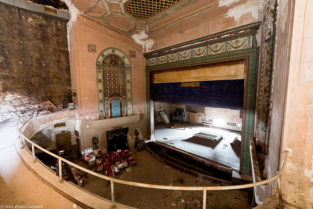
The theater was built in 1924 and was dubbed the "Showplace of the South" But the years of abandonment have taken their toll on the building. Water pours through holes in the roof every time it rains. The ornate crown molding is cracked, the plaster is peeling off in chunks, and the orchestra pit is flooded with murky water.

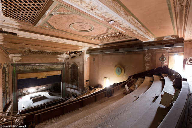
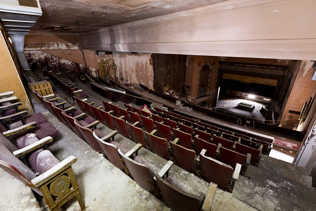
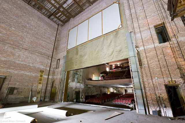
The damage to the building is most evident when viewed from the stage, which at one time saw performances from the likes of Judy Garland, Will Rogers and Harry Houdini. From here you can see the plaster wall that has collapsed onto the horseshoe shaped balcony, and the holes that poke through the ceiling above.

IMG_6448

The Saenger brothers built 300 theaters across the country, of which only about 100 remain. Two other Saenger Theaters were built in Arkansas, in Hope and in Helena. But both of those theaters were torn down and lost decades ago.

IMG_6451

IMG_6453

IMG_6464-2

The Saenger was used as a traditional theater until the 1960s, when it was converted into a movie theater. But competition from new movie theaters took a bite out of the Saenger's business. So in 1975, the theater closed. It had a short second life in the 1990s, when it was used for a few years by the Pine Bluff Film Festival. But when that ended, the theater was permanently closed.

IMG_6485-2

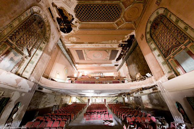
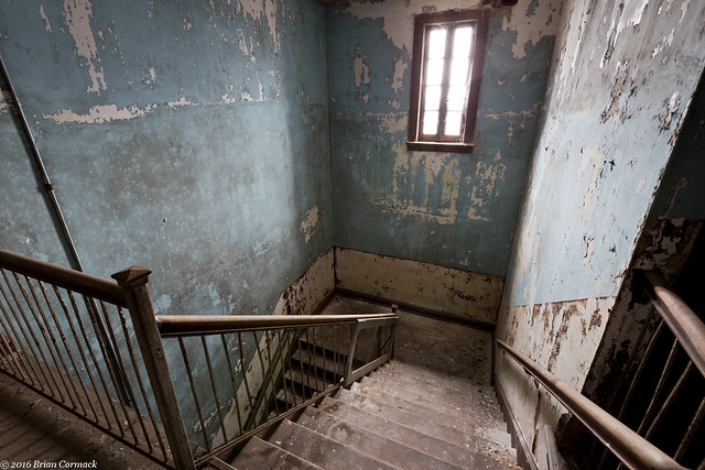
The architecture of the Saenger is also a sad indicator of the era in which it was built. A side staircase bypasses the lobby and heads to the top of the balcony, which was used by African Americans who were forced to sit there during the days of segregation.

IMG_6566

The view of the stage from the balcony:

IMG_6490-2

IMG_6506-2

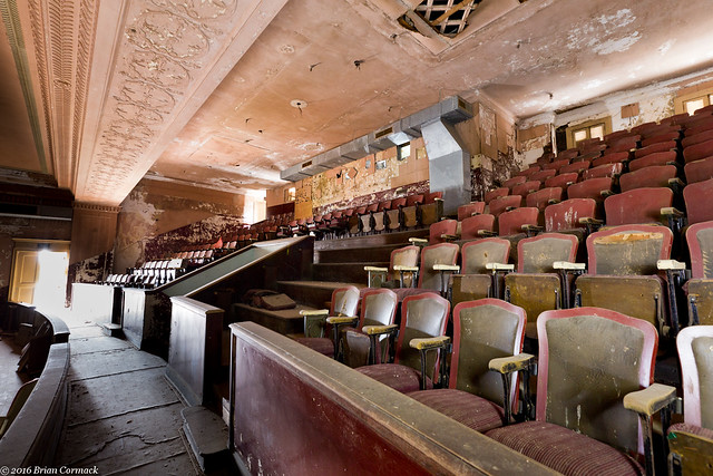
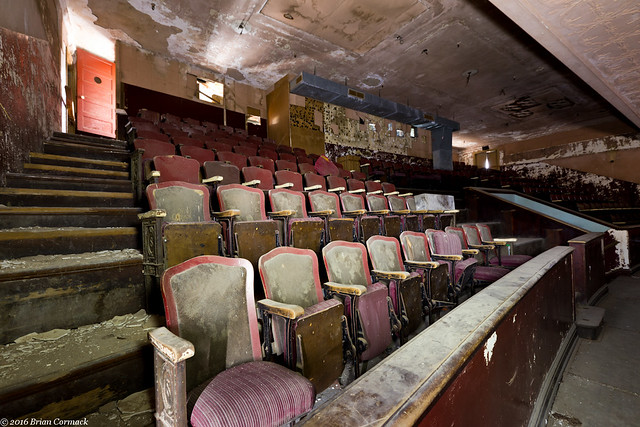
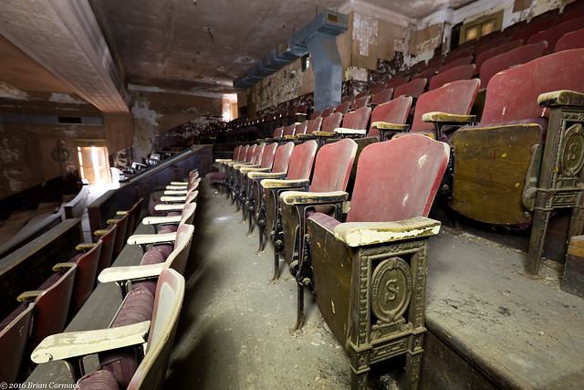
And the seats at the very top of the balcony, which are maybe the original seats? They certainly look old enough to date to the 1920s.

IMG_6501-3

IMG_6508-2

IMG_6559-3

IMG_6577-2

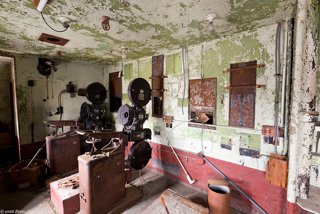
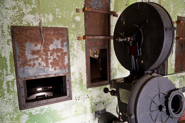
At the very top of the balcony is a narrow series of rooms, which included a tiny bathroom and the old movie projectors.

IMG_6512-2

IMG_6547-2

IMG_6556-3

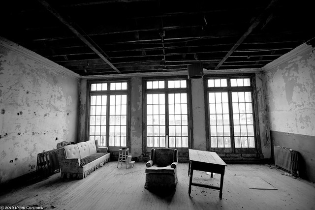
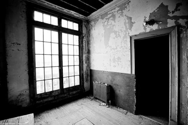
We headed back downstairs and went behind the stage. The theater was hard to take pictures in because the only light was coming through the few windows that weren't boarded up. As it got later in the day, it continued to grow darker inside the building.

IMG_6584-2

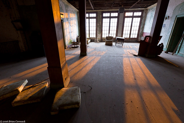
It was starting to get dark, and the streetlights outside began to cast an orange light through the windows on the second floor.

IMG_6589-2

The Saengler was nearly torn down in 2011. It was spared the wrecking ball and the city of Pine Bluff purchased the building. Since then, the building has sat empty and continues to deteriorate. The Saengler is one of many abandoned buildings that haunt the streets of Pine Bluff. It would be a shame for it to join the fate of the buildings there that recently collapsed into piles of rubble.  There aren't very many theaters like this left in the state, and if it is torn down than we lose a part of our state's history.  It won't be easy, and it won't be cheap, but the Saengler needs to be preserved.  Until then the Saengler sits, like the Hotel Pines a few blocks away, as a ghost awaiting its fate.

IMG_6595

Wednesday, November 30, 2016

Junction Bridge

While I was in downtown Little Rock last weekend, I headed over to the Junction Bridge to get a few pictures. The bridge is a popular connection over the Arkansas River, connecting the River Market on the south side to the Verizon Arena on the north side. The Junction Bridge was originally built in 1884. It was reconfigured in the 1970s so the bridge could handle larger barges passing underneath it. But the railroad would soon abandon the bridge. After sitting unused for several years, it was converted into a pedestrian bridge in 2008.

IMG_6409-4

The Junction Bridge actually sits right atop the actual little rock that gave the city of Little Rock its name. The rock was a small outcrop that jutted out from the riverbank, and is part of the foothills of the Ouachita Mountains. The rock got its name thanks to French explorers, who traveled up the river in 1722. After passing through the flat and meandering Delta, the explorers saw the small bluff and then a larger bluff upstream around a bend. They called the larger bluff The French Rock (or "le Rocher Francais" to be exact). It became known as Big Rock, while the smaller bluff became Little Rock.

IMG_6418-2

A town was eventually settled around the little rock, which quickly rose in prominence after it was chosen as the territorial capitol of the state (replacing the mosquito-infested and oft-flooded Arkansas Post). But as the new capitol city grew, steamboats began docking near the rock. As a result, the neighborhood around it became filled with saloons and brothels. Fights were routine in the area, so much that streets and alleys became known as "Battle Row" and "Fighting Alley." The neighborhood surrounding the rock was given the name "Hell's Half Acre."

So it's almost easy to see why it would be allowed for the little rock to be mostly destroyed to make way for a bridge, since it wasn't in what was considered to be the best part of town. Starting in the 1870s, large sections of the little rock were dynamited away and then unceremoniously dumped in the river. The Junction Bridge actually used the remaining section of the rock as an anchor for the bridge supports.

IMG_6427-4

Of course nowadays it would be unthinkable to destroy a landmark like that, but I guess historic preservation wasn't the top priority in the 1870s. But the conversion of the Junction Bridge to a pedestrian bridge has become part of the massive revitalization that has taken hold of downtown Little Rock in the past twenty years. The bridge itself is a true attraction (and one of the best places to get pictures of the Little Rock skyline). The neighborhood around the old "Hell's Half Acre" is again seeing large crowds with people flocking to the River Market and the many restaurants and bars that line the streets (although there aren't any brothels around there nowadays).

Monday, November 28, 2016

Hickson Lake

After a bit of a delay, we finally managed to get some good fall colors here.  The trees in central Arkansas began changing in the middle of November (only a few weeks after their usual peak).  To take advantage of the change, I decided to head to Hickson Lake, in the Dagmar Wildlife Management Area. The WMA sits near the White River in the flat lands of the Arkansas Delta.

When we got there, I was a little disappointed to see that while the fall color was at its peak, many of the trees had already lost most of their leaves. I suspect that they were blown away when a storm blew through a few days before. Oh well. It's still a beautiful spot. the lake is lined with thousands of cypress and tupelo trees. So here's a shot of a little bit of fall color, reflected in the still waters of the lake.

IMG_6184-4

Tuesday, November 22, 2016

Buffalo River

The fall colors this year have been very strange.  October was warm and dry, so the trees decided to wait and postpone changing colors.  So around Halloween, when the fall colors are usually at their peak in the Ozarks, the trees were still mostly green or brown.

But while the fall colors weren't going to be the best this year, I made the 3 hour drive up to the Buffalo River a few weeks back. I left before dawn, sleepily driving through the dark towards Steele Creek. I arrived just before sunrise, and the river was quiet (except for some deer running around and some early-bird campers getting up). But I was amazed when I headed down to the river and found some good color in the trees growing right along the river.

IMG_5808-3

Maybe being by the water, the trees here had slightly cooler temperatures which caused them to change. The trees on the mountains above the river were mostly brown or had already lost their leaves.

IMG_5816-3

As the sun was rising, I drove over to Boxley Valley. This is one of the prettiest spots in Arkansas, a scenic valley filled with historic homes and barns. The valley's resident elk herd was out in the fields, along with the throng of people perched on the side of the road trying to see the elk. I hurried past and stopped to get pictures of this old barn, which was built in 1915.

IMG_5849-3

And one last shot, taken behind a barn in Boxley Valley. The mountain in the background was beginning to be lit by the light from the sun, as the rest of the valley woke up.

IMG_5872-2

Wednesday, November 16, 2016

Alley Mill, Missouri

After leaving Klepzig Mill, we drove over to the campground at Alley Mill and set up camp. Early the next morning, before sunrise, we got up and then headed over to Alley Mill. The mill sits right next to Alley Spring, and is considered to be one of the most photographed places in Missouri (the St. Louis Arch is probably the most photographed place in Missouri, but no one was keeping track when we were there).

It is a beautiful spot. The three story mill was built in 1894 and has a commanding presence next to the waters of the spring.

IMG_5283

Alley Spring has a daily discharge of 81 million gallons, making it the seventh largest spring in Missouri. The spring gushes out from the base of a bluff, where it rushes past the Mill and then eventually flows into the Jacks Fork River.

IMG_5306-4

IMG_5314-3

Another view of the Mill, which continued to operate until 1925. That year, the Mill and surrounding property became a State Park. In 1972, Alley Spring was acquired by the National Park Service and became part of the Ozark National Scenic Riverways.

IMG_5335-2

The sun was about to clear the hills, so we took a few more pictures before starting the long four hour drive back to Arkansas. This last shot is of the tall bluff that surrounds the deep blue waters of Alley Spring.

IMG_5341-2

Monday, November 14, 2016

Klepzig Mill, Missouri

From Blue Spring, we drove off to find another old mill.  After some more driving (things are fairly spread out in the Ozark National Scenic Riverways), we finally headed down the bumpy dirt road that runs by Klepzig Mill.  The mill was built in 1912 by Walter Klepzig, the son of a German immigrant.  According to the National Park Service website, Walter Klepzig was considered to be a "progressive thinker."  He was the "first in the neighborhood to introduce both barbed wire and woven fence wire and a refined breed of milk cow" (how is a cow refined?  Does it hold up its pinky when it drinks tea?).

IMG_5181-2

Klepzig also apparently "routinely saved 'good boards' for use in building coffins for his neighbors," which is an odd little note to mention on the NPS website. It was probably a well-intentioned thing to do in the rough and tumble Ozarks in the early 1900s, but it's also a little creepy. "Hey Steve, nice to see you! By the way, got some great wood for your coffin. Have a nice day!"

IMG_5190-2

The mill was certainly built in a very scenic location, overlooking Rocky Creek. The creek lives up to its name, as it is filled with huge boulders and waterfalls. This is the creek as it rushes under the mill.

IMG_5194-2

Klepzig Mill was used as a both a sawmill and as a mill to grind corn. In the 1940s, it was also used to help generate electricity.

IMG_5209-3

And one last shot of the mill, taken while sitting just above a waterfall that was probably about 15 feet tall. The mill overlooks a section of the creek that swirls and drops between huge rocks before calming down a bit past the mill. It was a very scenic spot that was one of our favorite stops on the trip.

IMG_5274-6

We made one more stop after this, and visited what is probably one of the most photographed places in Missouri...

Wednesday, November 9, 2016

Blue Spring, Missouri

From Turners Mill, we headed on towards Blue Spring.  Eventually after some more driving, we headed down the dirt road that runs downhill towards the Spring.

IMG_4997-2

After a short walk, we made it to Blue Spring. The Spring is aptly named, the water here is a deep and vivid shade of blue. The Osage called this the "Spring of the Summer Sky," which is pretty fitting.

IMG_5062-2

The color is due to suspended particles of limestone in the water, and also because of the depth of the Spring. Blue Spring is one of the deepest springs in the country, descending 310 feet. It's deep enough that if you were to walk the Statue of Liberty here all Ghostbusters 2 style and drop her into the spring, she would be completely submerged all the way past the torch.

IMG_5068-3

About 90 million gallons of water flow out from the Spring every day, making it the seventh largest spring in the Ozarks. From here the water creates a stream that then flows into the nearby Current River.

IMG_5076-2

Along the short hike back to the parking area, we walked by this side trail which snaked off into the woods. After that we headed back to the car and then drove on towards a few more springs (there are a bunch of them in this area!).

IMG_5111

Tuesday, November 8, 2016

Turners Mill, Missouri

From Big Spring, we headed over towards Turners Mill and Spring. The Spring is actually located in the Mark Twain National Forest, not very far from the Eleven Point River. Along the way, we drove down a few bumpy dirt roads. The fall colors were a little past peak there, but the trees still made for a pretty drive.

IMG_4764-2

IMG_4820-2

We drove to the parking area, and then made the short walk to Turners Mill. The mill is all but gone now, the only thing remaining is a huge 25 foot tall metal waterwheel. The wheel sits in the creek, as the clear waters from the nearby spring rush past.

IMG_4862-2

Although there is no trace of it now (besides the huge wheel), the mill here used to be four stories tall. From what I could find online, the mill dates back to the 1880s. The metal water wheel was added later, in 1915. The wheel (which must weigh tons) was shipped in pieces, with oxen bringing it to this spot along the creek. The mill supported the small town of Surprise, which is also gone now. The only building left is an old school that sits along a short trail not too far away.

IMG_4878-2

The mill used the waters of Turners Spring, which flows out from a bluff just upstream from the waterwheel. Around 1.5 million gallons of water flow out from the stream every day, flowing down hill and past the waterwheel before emptying into the Eleven Point River.

IMG_4897-2

We then walked back to the car and continued on towards a few more Springs...