Thursday, April 28, 2011

Triple Falls (finally!)

After climbing out of Bear Creek, we returned to the campground and lazily sat around the campfire. After lunch, we all debated where to head out next. One of the other photographers up there, Bryan Simpson, decided to drive around and try to find some interesting barns to take pictures of. I always love a good barn, so I headed off with him.

We drove down a few different dirt roads, looking for something interesting. Eventually we ended up in Boxley Valley, which has a ton of neat barns in it. We stopped for a few pictures, but none of mine really turned out. As we headed out, we decided to pay a visit to Triple Falls, the waterfall near the Camp Orr Boy Scout camp along the Buffalo National River.

I was happy to make the trip. Triple Falls can be reached via a very short and easy hike (which was nice compared to the miles of bushwhacking done that weekend). And with the recent rains, it actually meant that all three of the waterfalls there would be running. On my previous visits to this waterfall, I have had bad luck. I've actually never been able to get up there when the falls have really been running well. The old joke was that it should be called Trickle Falls, since that is what I usually see it as.

The only problem with a waterfall visit was that my tripod was back at the campground, I had forgotten to pick it up. Luckily Bryan had a spare that I could borrow.

So we made the short hike to the falls, and they were indeed running quite well. I was thrilled to actually see them running like this, finally! But another problem popped up. The ball head on the borrowed tripod wasn't working right. It wouldn't lock down, so I had to try to rig it in a way to get it steady for a few pictures.

And luckily, it worked out!
P4161043

This is a really pretty waterfall, and a popular spot. As we were leaving, about eight other photographers showed up.
P4161067x

We spent the night again at the campground, and luckily the weather had calmed down. The sun came out and warmed everything up, and the winds died down. It was actually a pleasant night to sit out by the campfire and enjoy some good company.

The next morning we all woke up before dawn again, and set off to find a good spot to catch the sunrise. We ended up at a spot along Hwy. 7, with this view looking towards the east.
P4171105

And from there, we drove over and made the short hike to the waterfall in Lonesome Hollow.
P4171121

From there it was back to camp, where we started to pack everything up. I was tired and sore, and hadn't had a shower in a few days (and probably really needed one). So I gathered up my burned shoes, and we departed camp and headed back home...

Wednesday, April 27, 2011

Bear Creek

I woke up before dawn on a cold morning - it was about 36 degrees in the Fairview Campground. I'm not a fan of early mornings, or really being awake before noon on weekends, but I'll occasionally drag my lazy butt out of bed for pictures. The brain trust (made up of a bunch of photographers) had decided to head out at dawn and visit a nearby creek that features some amazing waterfalls.

The weather people had predicted that it was going to be sunny that day, so the plan was to hike to the creek before the sun was up high enough to cause any problems. Luckily, some uncontrollable shivering (along with some caffeine) helped get me alert enough to do some hiking.

The creek we planned on visiting is Bear Creek, located in the Ozark National Forest. There are several cool waterfalls along this creek, and the recent rains meant that we would catch them with some decent water flowing through. Bear Creek sits just south of Hwy. 123, near Pelsor. If you have driven to the Buzzard Roost hiking trail, you've actually driven right by this creek.

The trailhead to the creek was just a short drive away from our campsite. We parked along a dirt road and set off, again, into the woods. We passed by a small swamp, which is somewhat unique. You don't really see many swamps up in the Ozarks. Let alone a swamp that sits on the top of a mountain. We walked along the edge of the swamp, and started to bushwhack downhill.

It was steep, but it seemed a bit easier compared to the hike out of Mose Freeman Hollow the day before. Eventually we made it to the creek, right next to a pretty spectacular waterfall:
P4160755

This is Sidewinder Falls, where Bear Creek zooms down and then makes a sharp turn. In the distance, partially obscured by a fallen tree, is Swamp Falls.

Another shot of Sidewinder Falls:
P4160761

And a closer view of Swamp Falls. It was hard to get a good shot of these falls from the hill above the creek. There were lots of trees in the way...
P4160780

We hiked further down, eventually making our way to the creek.
P4160798

From here you had to cross Bear Creek in order to get to the next waterfall. The spot where I decided to cross was about knee-deep. The water was cold...

But it was worth having wet shoes. Bear Creek is almost literally a photographer's playground - in that there is an awesome slide here (please note that you can't actually slide down this waterfall, that would just be silly. However I have heard of people kayaking down it). A large boulder has fallen onto the creek, causing the creek to split into a V as it falls into a slot canyon.
P4160855x

This is V-Slot Falls, which must be one of the cooler waterfalls I've seen. The slot canyon curves around, and is probably somewhere around 10-15 feet deep.
P4160821

After taking many pictures there, I packed up and waded back across the creek above the falls. We headed past Sidewinder Falls and went to another waterfall upstream. This is the view along the way:
P4160901x

P4160904

And after a short hike, we found this other great waterfall (all of these falls were located along a fairly short section of the creek). This one wasn't named in the Tim Ernst guidebook, but we have taken to calling it the Little Punchbowl Falls.
P4160928x

And another view of the falls, which is a pretty neat little spot.
P4160953x

From there we started to make the long hike back up the hill. My legs, which were already sore from being asked to exercise the day before, were protesting whenever the hike reached a steep spot. But the pain was worth it - this really was one of the most prettiest places I've visited in Arkansas.

And sorry this is kinda short, and not filled with the typical wit and brilliance you find here (yeah right!). I've been half typing and half watching a soccer game tonight.

Tuesday, April 26, 2011

Mose Freeman Hollow

From Brushy Creek, we headed to explore another spot in the Ozark National Forest that very few people have probably visited or photographed. This hollow is located just east of Highway 7, near Mocassin Gap. We parked the car along a dirt road, and tried to find a good spot to access the creek.

Even from the top of the hill you could tell that the creek was promising. From above, you could hear a loud racket and commotion coming from the creek. Which could only mean one thing - waterfalls. So we started heading down the hill, which was not easy. This hill was typical of the Ozarks - lots of sharp rocks sticking out of the ground, with a good deal of debris from the 2009 ice storm haphazardly laying around. And on top of this, sitting like frosting on a cake, was a thick layer of poison ivy.

The hillside was very steep, and I was already dreading the hike back up the hill. But we made it to the creek, and immediately found a waterfall.
P4150701x
This waterfall is unnamed, and one of the names suggested for it was Lucky Falls. Lucky, being that we were lucky to survive the climb in and out of the hollow. And I might add, also lucky to have not left behind a wallet, car keys, or cell phone down there. And then, also lucky that no one suffered any ill effects from the sea of poison ivy that we waded through.

Instead of trudging back up the hill, we decided to explore more of the creek. The ground above the creek was still very steep, and covered with fallen trees. It was actually much easier to just walk through the creek. So we headed downstream, even walking down this natural water slide.
P4150709
Which, surprisingly, wasn't slick at all. The only time I slipped around there was when I was safely at the bottom of the falls.

P4150713x

We headed further down and found another good waterfall:
P4150724

Lower Mose Freeman Hollow Falls:
P4150736x

From there we explored a bit more of the creek, finding a few more smaller waterfalls:
P4150749x

We had put off the inevitable long enough, and it was time to trek back up the hill. The hope was that we would have found a spot to head uphill that wasn't quite as steep. But that never happened, so we slowly slogged up the hillside. I'm not exaggerating in saying that it was one of the most difficult hikes I've ever tried to do. By the time we reached the top of the hill, my legs and knees were already sore.

There was a welcome prospect of having a warm campfire waiting for us, however. We were meeting up with a great group of photographers at the Fairview Campground. We got there before dark, and were greeted with strong winds and cold temperatures. Fairview sits atop a mountain, so the winds are always much stronger there. The temperature dipped down in the upper 30s overnight as high winds buffetted the campground.

I went to another photographer gathering last year at Fairview. It was on that trip that I lost a pair of hiking boots to the campfire. I had set them by the fire in an attempt to dry them out, but a log from the fire rolled out and just happened to land right on top of my shoes.

At the gathering this year, everyone was huddled around the same campfire trying to keep warm. The wind was so strong that you actually had to stand pretty close to the fire to really feel any heat. So it should come as no surprise that the fire again claimed another one of my shoes. An ember escaped the fire and managed to land right on top of my shoe - while I was wearing it. I dumbly didn't even notice that it was slowly burning a nice hole in the top of the shoe.

Wednesday, April 20, 2011

Brushy Creek

Arkansas is a fairly small state, so I'm amazed that there are still numerous places out there that haven't really been explored or photographed. After all these years, there are still some spectacular places that are well off of the beaten path - literally, since there aren't any trails through there and it's all a matter of bushwhacking through the woods.

The Blue Hole, in the southern reaches of the Ozark National Forest, is one of those places. Sure it has seen a few visitors before, but it isn't listed in any of the guidebooks, and there are no signs telling you how to get there. It's a place that I had been wanting to visit again, and finally had the chance last Friday.

I took the day off from work and met up with Zack Andrews and Matt Kennedy in Conway. I left before dawn, and hoped that the clouds would stick around. But as we left Conway and headed north, the clouds disappeared and were replaced with a brilliant blue sky. That would be fine, except sunny weather is the mortal enemy of waterfall photography.

But we continued on, intent to explore part of Brushy Creek (which flows through the Blue Hole). There are several waterfalls up there - I had heard of one that looked really neat (thanks Terry!), and we set out to find it. Zack also spent some time analyzing the topo maps and found a few drainages that looked promising.

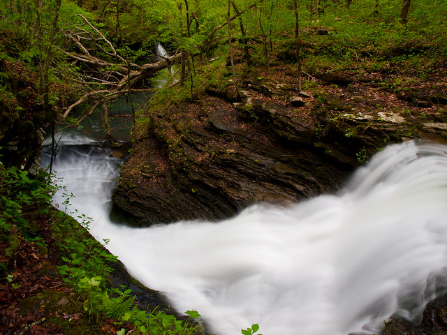
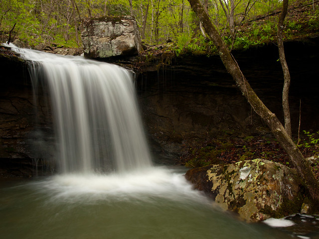
We parked on the side of a dirt road, and set out into the woods. Quickly enough, we started heading downhill and alongside a small creek. The creek turned into a long cascade, which eventually emptied into a small waterfall. I set up the camera to get a few shots. Luckily it was still early enough in the morning that the waterfall was in shadow. But the sun was beginning to creep in - you can see the light hitting the trees in the top of the shot.
Waterfall hunting

Before too long the sun was out, which kinda ruined the good light needed for taking pictures. But we headed on and explored more of Brushy Creek. There was no trail, of course, but it was fairly level by the creek with just a few hills to scramble over. The worst thing about the hike were the briar patches. There were thousands upon thousands of thorns out there, which seemed intent on catching and snaring anything they could find. I spent most of my time on the hike trying to untangle myself from thorny vines, or from dodging thorns that seemed destined to scratch at my face or eyes. By the end of the hike, my arms and legs were covered in scratches (don't know how it got my legs, I was wearing pants after all). I looked like I had barely survived a mauling during a cat fight.

But we explored a few of the drainages that empty into Brushy Creek. The first had a waterfall that looked a lot like the first waterfall we visited. But the second drainage was amazing - it had a long cascade that dropped down into a small pool that was flanked on one side by a tall bluff. But of course, the sun was shining down and the pictures weren't coming out right.

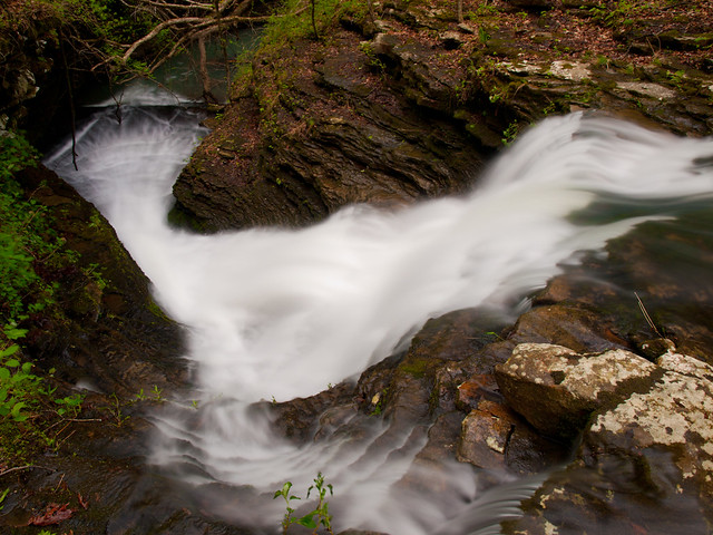
The third drainage we visited had another great waterfall, where a creek went over a nice waterfall before jumping and diving around a few rocks. But the sun was out, so the pictures were crappy.

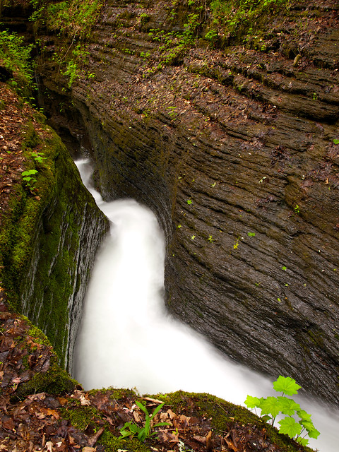
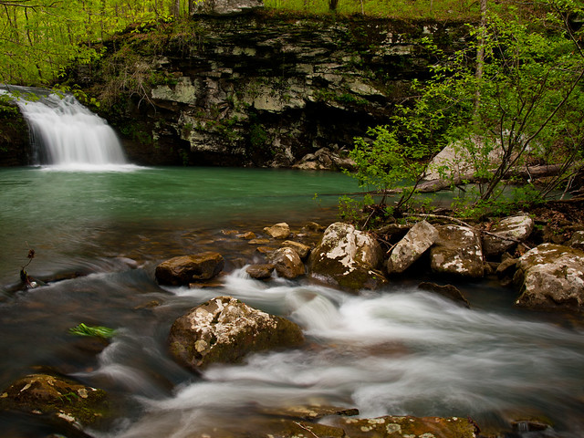
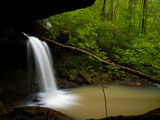
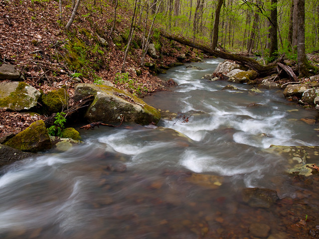
But amazingly, as I made my way through the army of thorns towards the fourth drainage, a miracle happened. Clouds appeared and blocked the sun. Yes! It actually looked like a thick layer of clouds had appeared, which would help in getting some good pictures of this great place. I stopped and got a picture of the creek that flows out of the fourth drainage...
Partly cloudy

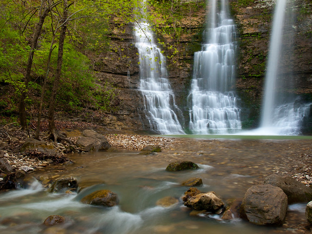
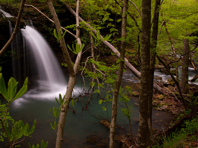
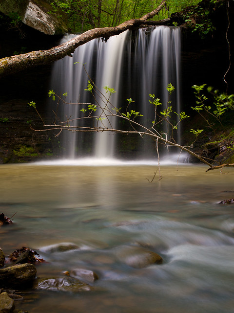
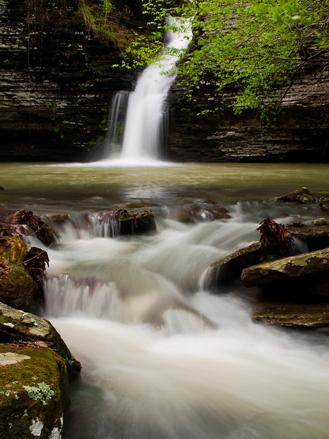
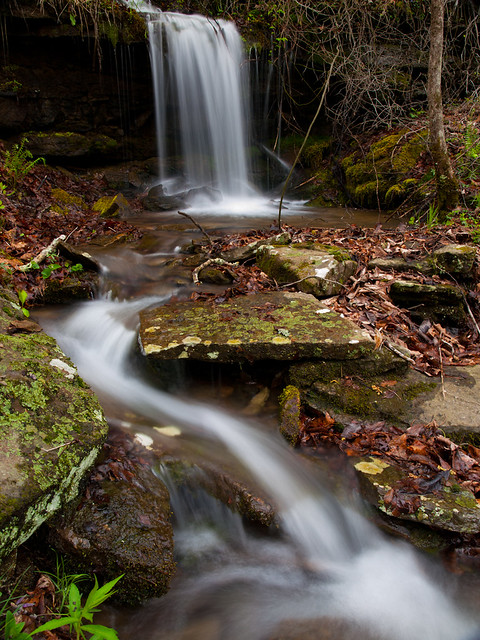
The waterfall at the end of this drainage is beautiful. The creek has carved a gorge through the bluff, where it tumbles into a pool surrounded by a grotto.
Brushy Grotto Falls

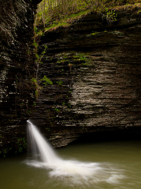
A view of the front of the falls, which we have named Brushy Grotto Falls:
P4150520x

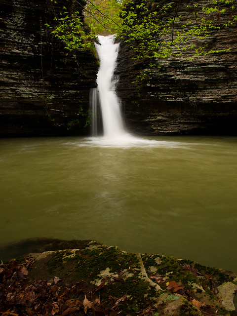
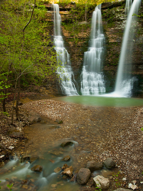
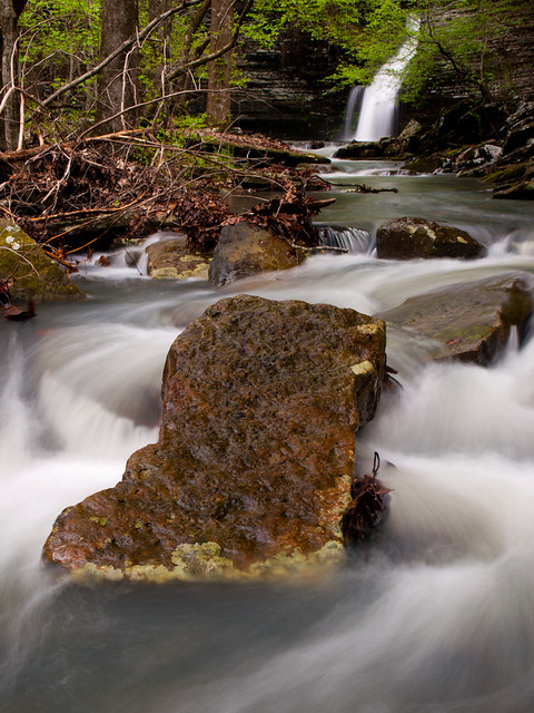
And from the opposite side:
P4150502

This is an amazing spot! And luckily the light was cooperating with us, and stayed cloudy.
P4150552xx

P4150568x

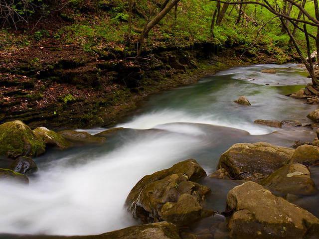
From there we hiked back to the creek and tried to decide where to go next. Zack wanted to visit some other drainages, but they were on the opposite side of Brushy Creek. To get there meant having to wade the creek, which would be a crossing through waist-deep water. I wasn't brave enough to do that, at least with my camera, so Zack set off to see if there was another waterfall up there. And indeed, there was. He found two cool waterfalls, including one that is over 80 feet tall.

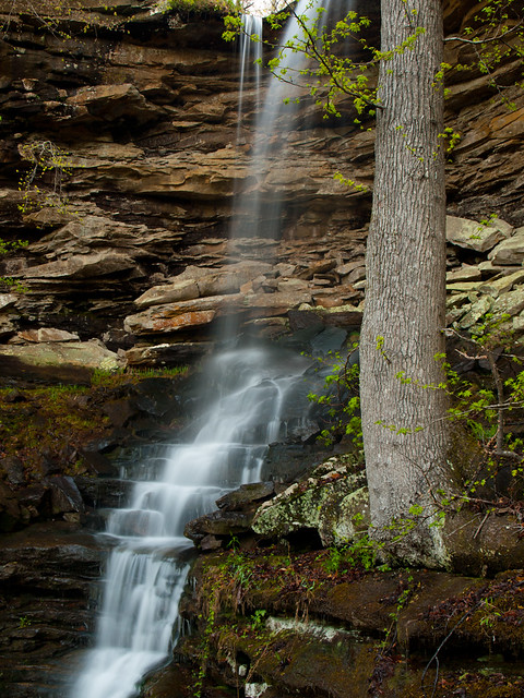
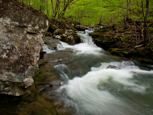
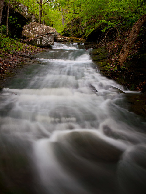
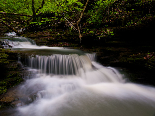
I wanted to backtrack and pay another visit to the waterfalls that we had been to earlier when the light was bad. So I waded back through the thicket of vines. Here is the drainage where the creek cascades down next to the large bluff:
P4150638
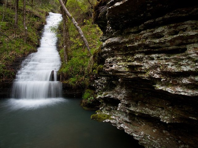
This waterfall isn't named, as far as I know, so I'm going to call it Hartman Falls.

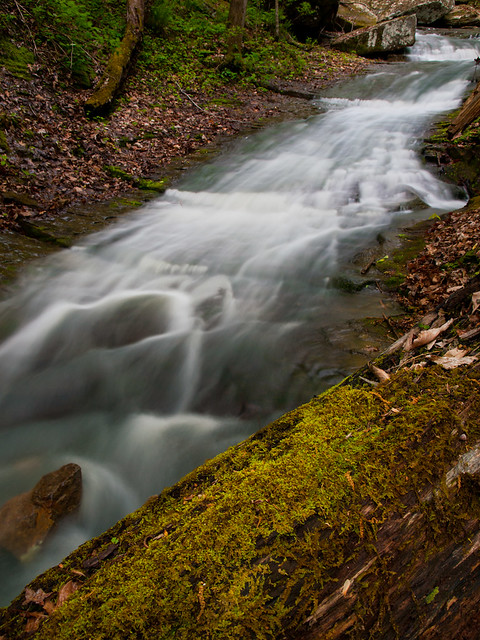
And a closer view of the cascade:
P4150649

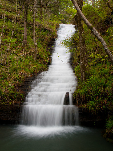
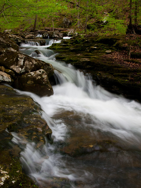
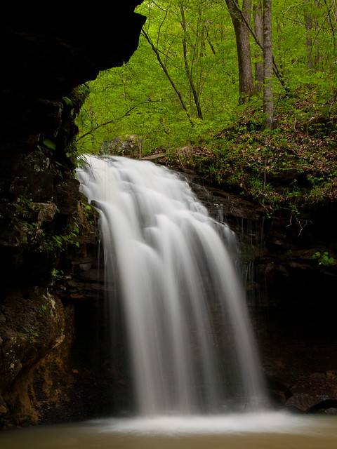
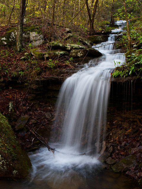
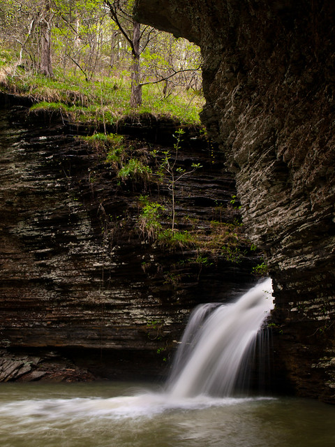
And the neat waterfall that's located in the second drainage we visited:
P4150584x
This waterfall probably hasn't been named yet, so I'll just call it Shea Falls.

P4150598x

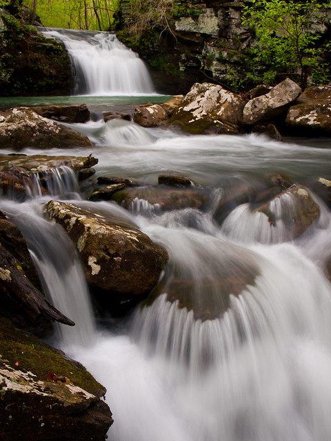
And the waterfall in the first drainage:
P4150624

We eventually all met back up with each other, and headed back up to Zack's jeep. Now where too next? We actually ended up exploring another creek, which has its share of neat waterfalls on it...