
So did you hear about the guy who went to climb Pinnacle Mountain last week and fell, breaking something like both ankles in the fall? Apparently the young lad climbed Pinnacle a few times a week, so he knew the trail. Well he fell down and passed out for awhile. His Mom got worried when he didn't make it home so she called his cell phone, and the ringing off the phone woke him up and his Mom called rescuers to get him, which they did do, and got him off the mountain.
So I had an idea to go out hiking again last weekend, and since the area I had decided on included a few cliffs with nasty falls, I was a wee bit paranoid. So I recruited a friend to tag along, mostly to ensure that I didn't fall off a mountain somewhere and go missing for a few days. Good times!
The friend this time was Will, who I guess decided to spend a day in the woods to get away from having to do household chores. A day in the woods would sure beat housework, right? I think by the end of the day he might not have agreed to that.
The idea for this trip were a few places that were maybe a tad bit closer to home, and places that I heard were scenic which I had never been to before.
The first place was called Buzzard's Roost, where a 2 mile hike takes you to the top of a neat bluff area looking over the Ozarks. The drive took us up from Russellville (past Booger Hollow) up into the hills. The trees up there were starting to get green after a late freeze killed off most of the leaves. There was actually a lot of green out, though most of it seemed to be poison ivy.
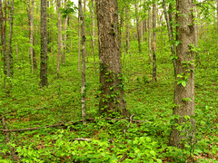
The trail was a somewhat easy hike, just a few hills to deal with. The trail was easy to follow since it was a 4-wheeler trail. Luckily no one came zooming around while we were out there...
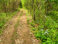
But at the trail head there wasn't much parking, so I parked in an open space, which turned out to be the trail itself. I actually unintentionally parked my car right in the way of any rednecks wanting to ride their 4-wheelers along the trail. This too made me a bit worried since I figured that they would get mad and slash my tires or set my car on fire or something. Luckily no one did come through, and actually we ended up having the entire trail to ourselves.
After hiking for a bit we finally came upon the cliffs, or well the "buzzard's roost," if you will.
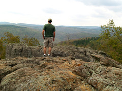
The cliffs are actually a neat area, the bluffs have been very weathered to form lots of interesting shapes. It was a bit difficult to climb out there since the neater rocks involved scrambling around while a huge drop-off was right below you. 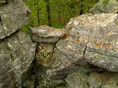
I did actually check my cell phone to make sure that I had a signal out there - just in case...
And amazingly, I did, though it was roaming. Luckily, I didn't get to test gravity and fall off the mountain, so it wasn't needed.
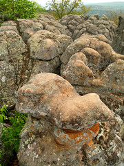
This is as far out as I braved to go...
The area at the bottom is pretty cool, and you can actually go to the bottom there and explore, which we did after I took a few more pictures up top and tried to figure out how to get back from rocks without somehow falling down to the bottom.
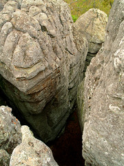
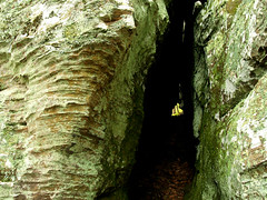
The bottom was neat, mostly it was like a series of caves set back into the bluff...
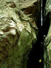
There was one part where the cave area shrunk down to a passageway that was maybe only a food wide.
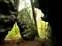
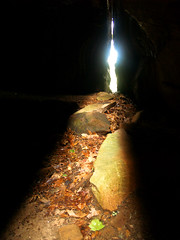
The neat thing is from here you can see the break in the rocks where light is coming through.
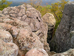
This view is from halfway inside the cliffs looking out to the area where the above picture was taken...
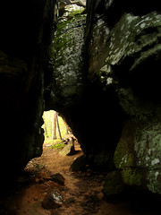
And the other end of the cliffs here:
Another neat aspect of Buzzard's Roost is that it has a natural bridge, or arch. According to my guidebook, it is "one of the largest and most impressive in Arkansas!" So we set out to find it. The guidebook stated that "you will have to bushwhack across a steep hillside to find this big arch - just follow the contour to the north at the same level from the little arch or top of the first bluff, across a small drainage, and then to the beginning of the next bluff - not recommended for everyone since this is a really steep scramble. The big arch is located 100 yards into the next bluffline." Sounds easy, right?
So we tried and set off bushwhacking (which is fun since that word makes me giggle). Off the trail the hillside was covered in acres of poison ivy, which we marched right through. We walked and walked, and I'm embarrased to admit, could not find the arch at all. We even went back up the hillside and hiked a side trial which I thought might just lead to the arch, but no luck. So then we gave up and headed back to the trail and to the car.
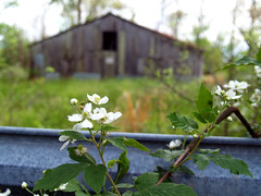
At the trailhead I was happy to see my little Hyundai was safe and sound. Next to the trailhead there was a neat little barn:
And then we hit the road! Driving out we made it to the safety of the paved highway and onto the next destination: Pam's Grotto Falls. This area is northeast of Clarksville, right next to Haw Creek Falls. Since Clarksville was my old college stomping grounds, I actually made the trip to Haw Creek Falls many times to take pictures. Haw Creek Falls are nice, but not that tall, and I never knew these other falls existed. Since I found out about them I've been eager to go out and visit the area again.
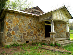
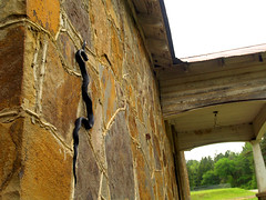
We drove west on Hwy. 123 over a neat little one-lane bridge over Big Piney Creek. On the other side of the bridge was a neat old building, which I guessed was an old church of some sort since it was sitting next to a cemetery. The building was right next to a parking lot for the Ozarks Highland Trail, so I of course turned the car around and zoomed back to try to get a picture. We weren't the only ones at the building though....
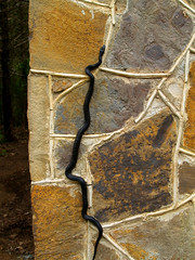
This giant snake was just hanging out - literally - right on the side of the building. I didn't realize that snakes could climb like that and just sit there. It was a bit creepy. I got a bit paranoid there about snakes, seeing sticks on the ground and thinking they were snakes, stuff like that. The lowest moment came when I was taking a picture, and out of the corner of my eye saw something black zoom around. I let out a yelp - probably more like a girly scream - and jumped back. The ferocious attacking creature? A butterfly.
So back on the road, which wasn't that far from Haw Creek. I parked the car in a neat area that I had never visited, which was downstream from Haw Creek Falls. The little area had access to the creek, and I was happy to see that the water was up and running.
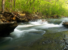
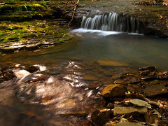
A small creek drained into Haw Creek there, with a neat little waterfall:
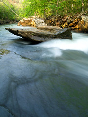
The area was very cool. There was a huge boulder sitting right in the middle of the creek:
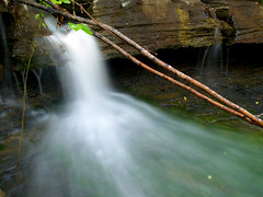
The trail to Pam's Grotto starts out across the road from where we were at, so we headed that way and walked a bit along the creek. There was a neat little waterfall there:
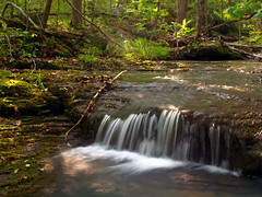
The weather had been a bit wacky all that day. It was overcast and cloudy most of the time when we were at Buzzard's Roost, but the sun was trying to break out when we started hiking the Pam's Grotto trail. The sun was in the way while I was trying to take the shot, so I just went ahead and included it there since it wouldn't go away:
Usually, direct sunlight like that isn't recommended for waterfall pictures. But luckily the sun went behind a cloud and wan't much of a problem the rest of the day.

The trail to the Grotto isn't that long at all - half a mile, actually. When looking at the guidebook I didn't seem to notice extra information next to it - especially the part that said "Medium hike/bushwhack." I had just assumed that the trail would follow the creek to the Grotto and the trail would be an easy hike. That was an amazingly wrong assumption.
The guidebook had this to say about the trail: "Follow the trial up the hill .25 mile to the base of the big bluffs." What it should say is, follow the trail straight up the hill, in a trail that will kick your arse and remind you how out of shape you truly are. Because that's what the trail did. It was a steep, steep trail. It had an elevation gain that would make Pinnacle Mountain envious. It hurt, and it seemed that it would never end.
The Trail of Doom, I later learned, was actually built to provide access for rock climbers to reach the bluffs overlooking the creek. How anyone could have enough energy to go rock climbing after that trail is beyond me.
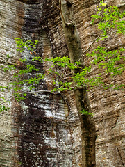
The view of the bluffs, or the Bluffs of Exhaustion, after making it up the Trail of Doom:

Hiking along, I did something very stupid. I was messing around with the camera and managed to drop my polarizing filter. These filters are dead useful for waterfall photography, and my filter was still fairly new. It fell to the ground and managed to bounce and roll down the hillside. Luckily it didn't make it too far, which is good because that little piece of glass is insanely expensive. That filter cost me $50. It seemed to work ok after its excursion down the hill, but if it were to mess up it wouldn't be the first time that has happened. I've gone through several filters over the years.
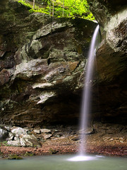
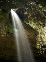
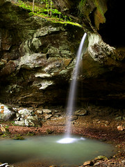
And while hiking along the (thankfully) level trail below the bluffs, you start to hear the loud sound of water falling. There is a bend in the trail and then the Grotto itself finally comes into view. There is a bit of a scramble down the hill to the grotto itself, but it was worth it. The area isn't that big but does have a lot of personality:
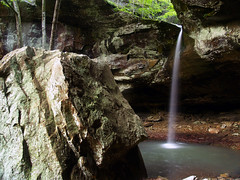
The falls are 37 feet tall, and the pool at the bottom is guarded by a large boulder.
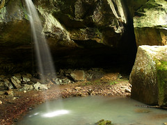
It was a cool area, I wish I had more time to explore there. You could easily spend hours and hours there.
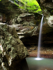
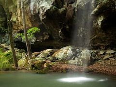
A side view of the falls:
And a view from behind the falls:
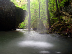
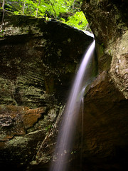
The whole grotto is very beautiful, so please forgive me for showing off a few of the shots here:
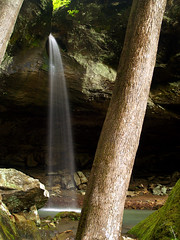
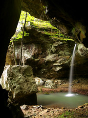
The grotto also includes a large overhanging bluff, and this is looking at the falls from under the bluff...
It was starting to get late, so it seemed like it was just about time to pack everything up and head back home. Not before one last shot, though:
Since the Trail of Doom was easy to handle going downhill, the trip back was quick and uneventful.
It was a good trip, and I'm glad I managed to finally visit a neat waterfall area that I had been next to many times before. When I got home I was looking through another guidebook (Arkansas Waterfalls Guidebook by Tim Ernst, actually) and found yet another waterfall in the same area that I had never been too. It's called Hobo Falls (the book doesn't say how it got that name), but the trail is only 4 miles or so south of Haw Creek. So I guess I have a new place to check out when I can make it up there next. The only thing - this trail is also listed as "medium hike," so that makes me nervous.

No comments:
Post a Comment