Sunday, May 31, 2020

Balanced Rock Falls & Leatherwood Creek

From Magnolia Falls, I rushed down the mountain into Boxley Valley in an attempt to see a few more waterfalls while there was still some good conditions for taking pictures. I parked and crossed the river at the Ponca low-water bridge and then headed off into the woods following a small trail that runs alongside Leatherwood Creek.

I have been in this area countless times but have never really noticed this creek, which flows into the Buffalo River by the low-water bridge. The creek is very scenic, with several small waterfalls along its run.

IMG_2589-2

The creek also forms a few shallow pools, like in this spot where the water was perfectly still and created some nice reflections.

IMG_2600-2

Further upstream was this birch tree and its extensive roots, towering over the water.

IMG_2611-2

And one more little waterfall, taken as the sun began to break through the clouds (much to my dismay).

IMG_2614-2

From here it was a steep little ascent up a muddy hill to Balanced Rock Falls, which isn't all that tall (maybe 15 feet?). But it is definitely unique, with a massive boulder perched precariously above the falls. It looks like if you were to mess with any ancient relic nearby, the rock would dislodge and start rolling towards you like in an Indiana Jones movie.

IMG_2620-3

I slid back down the hill to Leatherwood Creek, and managed to see one more little waterfall before the sun was fully out...

IMG_2626-3

Thursday, May 28, 2020

Magnolia Falls

Last weekend I wanted to try to squeeze in one last waterfall visit in before the heat of the summer sets in for good, and decided to do the hike to Magnolia Falls. The weather prediction wasn't really that great for waterfall photos, showing that it would probably be mostly cloudy all day (which meant that it would either be bright and sunny or pouring rain, probably). So I made the uncomfortable decision to do the hike right at sunrise, in the hope that even if it was sunny I could still see some waterfalls before the sun was too high to ruin pictures. But this meant I had to leave the house around 3:45 AM, and then drive up to the Ozarks (at least there wasn't any traffic!).

One other reason why sunrise seemed like an ideal time was because this was over Memorial Day weekend, which meant that all the trails would probably be crowded. I hoped the early morning start would mean there would be less people out and about (which was true, there wasn't anyone else out there). But I finally arrived shortly after sunrise, and started the hike to the falls. Maybe it was because my last hike was the long six mile trek to Smith Falls, but the hike to Magnolia was delightfully easy.

IMG_2452-2

After about a mile or so of hiking, the trail drops down to the waterfall. Magnolia Falls is small (only 26 feet), but it is amazingly beautiful. The pool around the falls was covered with vibrant moss and ferns.

IMG_2420-2

IMG_2391-3

The pool below the falls isn't very large, but it is scenic enough that you can find lots of different angles to shoot from.

IMG_2361-2

IMG_2409-2

IMG_2399-2

IMG_2416-2

Since it was still cloudy I wanted to hurry off to visit another waterfall, so I hurried back up the trail towards the car.

IMG_2497

Along the way, the trail runs alongside an old stone wall that was constructed by a pioneer family (probably in the late 1800s?).

IMG_2542-2

The wall stretches for about a quarter of a mile. The old homestead here is long gone, the only evidence that remains is this old wall. I can't imagine how difficult it must have been to dig up these rocks and place them here in such a way that it is still standing after all this time.

IMG_2534-2

Magnolia Falls sits within the Upper Buffalo Wilderness of the Ozark National Forest, and it appeared to be well taken care of. I didn't see any vandalism or litter along the trail. Hopefully we can all be good stewards of the forest and keep it that way.

IMG_2575-2

And one last shot from the trail, before making it back to the car...

IMG_2573-2

Thursday, May 21, 2020

Lower Ken Smith Falls

The Buffalo National River has recently reopened, and Zack and Matt and I decided to make a visit to the area to visit a few waterfalls. Of course we weren't the only ones with that bright idea. Boxley Valley was crowded with people who were going kayaking - there was a steady stream of cars heading off towards the Hailstone run. There was also lots of people who were standing around Cave Mountain Road trying to decide where to hike since the Lost Valley, Whitaker Point and Glory Hole trails were still all closed.

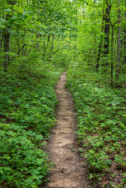
We decided that the best way to avoid the crowds (and any possible Rona exposure) would be to find a trail that was a bit more "off the beaten path." We decided to try to visit Smith and McClure Falls, which are located in Hawk Hollow in the Upper Buffalo Wilderness Area. Of course any trails up there were bound to be busy, and there were already two cars parked by the trailhead when we arrived. I say that this is "off the beaten path," but that might not necessarily be true anymore. When I last hiked this trail in 2014 while going to Bowers Hollow, it was still mostly a bushwhack. But this time there was a well-defined trail that ran off into the woods. It’s amazing how popular all these waterfalls have gotten, and just how many people are out in the woods now (which may or may not be a good thing).

The hike to Hawk Hollow is long - about six miles total. A good chunk of it is relatively easy, since the trail follows an old road trace. Since it had rained heavily the night before, the trail was soaked with water that created deep puddles and in some places flowed down the trail like a creek. When we started the hike the weather was perfect for waterfall photography - cloudy and rainy. But of course, after several miles of hiking the sun decided to break through the clouds. Brilliant blue skies shined through the gaps in the trees above.

We stopped to rest at a spot where a creek crossed the trail. The creek was lined with thick green moss, so thick it was like a natural shag carpet.

IMG_2270-2

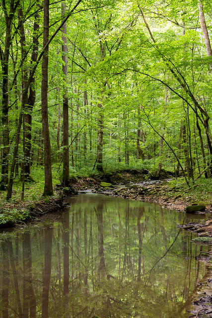
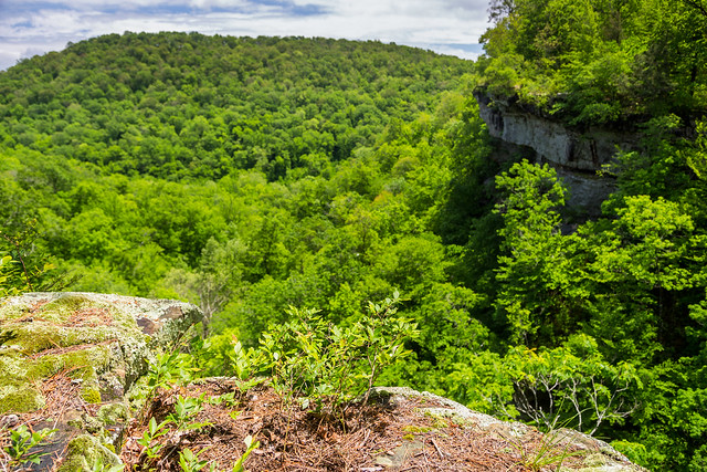
We followed the trail as it hugged the bluff line, which provided this expansive view of Hawk Hollow below. You could see part of the waterfalls from here, but to get close to them would require a steep descent into the hollow.

IMG_2268

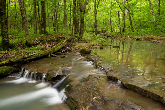
We eventually dropped down into Hawk Hollow, which was a steep and difficult bushwhack. We somehow missed the waterfalls on our way down, and ended up following the creek all the way to where it flows into the Buffalo River (which was running high and muddy after the rains). After backtracking uphill through the hollow, we passed by this neat spot. The tree canopy was so thick that it was barely letting any light through, and the light that did break through hit the creek like light from a disco ball.

IMG_2293-2

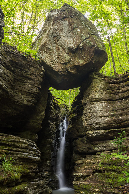
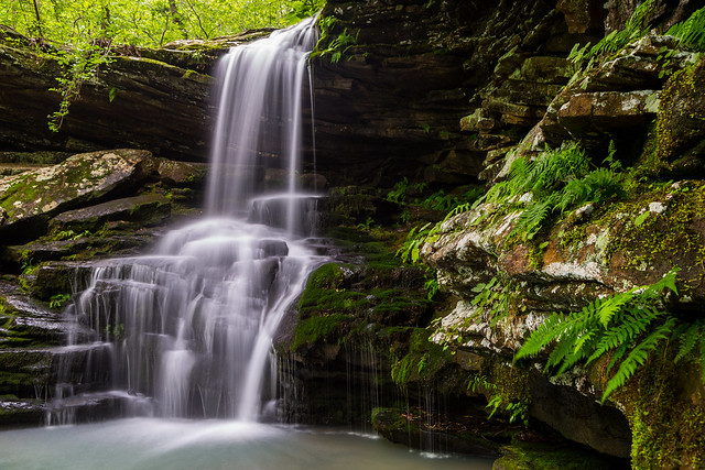
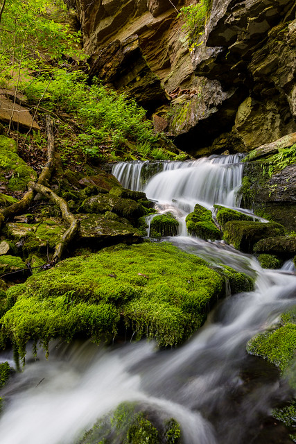
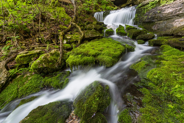
Heading further up the stream we passed by this waterfall (which was probably about 10-15 feet tall). It was sitting in almost full-sun, but I set up the tripod and hoped that a passing cloud would cause enough shade for a few quick photos. After waiting and waiting and having no luck, I took this sunny picture anyways since it was such a neat spot.

IMG_2297-2

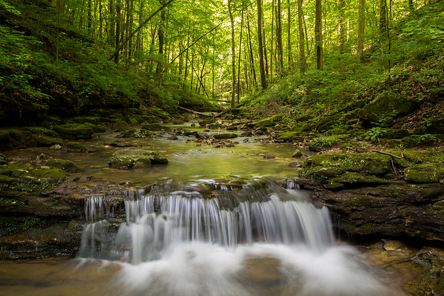
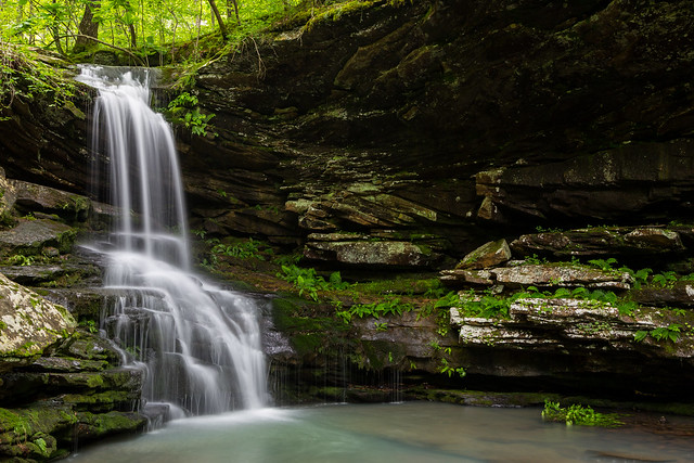
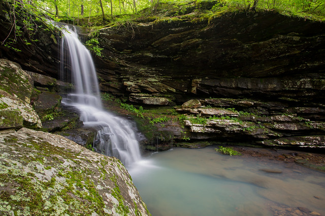
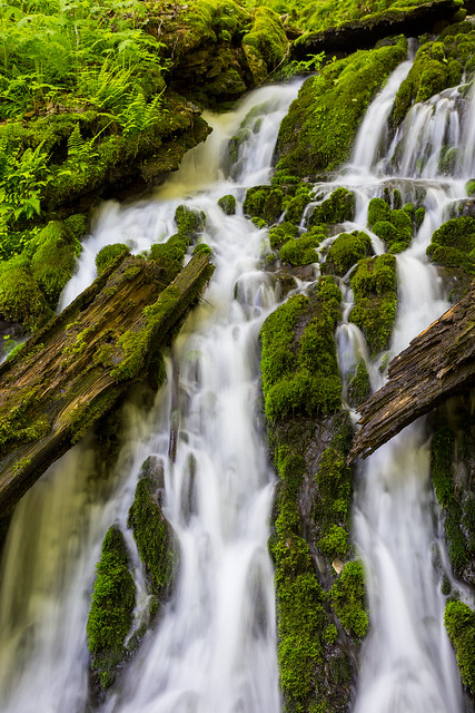
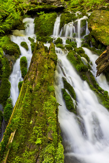
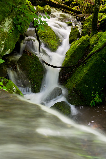
Further up the creek was another neat little spot, where the creek fell over a wide waterfall that was probably about 10 feet tall. A smaller waterfall flowed by next to it, tumbling over moss-covered rocks.

IMG_2315

Eventually we made it to the mighty Lower Ken Smith Falls, which clocks in an impressive 72 feet.

IMG_2321

Most of the falls were in shadow, but sunlight was hitting the top of the falls and then streaming into the pool below. Mist from the falls was caught in the beams of sunlight shining above it, like if someone was holding a flashlight above us.

IMG_2344

From there we hiked up the hollow and passed by McClure Falls, but we didn't stop for pictures since it was sitting in direct sunlight. I struggled up the hill and eventually we made it back to the trail, and then a few miles later made it back to the trailhead. It is a very beautiful spot, and one that would be worth visiting again (on a nice and cloudy day).

Wednesday, May 13, 2020

Marshall

Another little spot up in the Ozarks is the small town of Marshall, the county seat of Searcy County. Marshall is named after an old US Supreme Court Justice from the 1800s, and not (as I had hoped) after the firefighting pup from Paw Patrol. But just outside of town was this old building, seemingly abandoned and sitting in a field of wildflowers.

IMG_2247

IMG_2254

Monday, May 11, 2020

Yellville

Marion County sits right along the northern edge of Arkansas, and sitting near the middle is the county seat of Yellville. Across the street from the quaint little courthouse is the old J.C. Berry's Dry Goods Store. The two story limestone building was constructed in 1903 and served as a dry goods store until 1912 until it was converted into a hotel. The hotel was open until 1952, and then turned into a mix of apartments and stores.

IMG_2218

Wednesday, May 6, 2020

Slippery Hollow

Slippery Hollow has to joint the ranks of one of the most aptly-named places in the state. The state natural area near Yellville is home to several springs, which have turned most of the rocks around them into a natural Slip 'N Slide.

IMG_2126

IMG_2142

The springs are reached by a somewhat steep and rough bushwhack that seemed like it was mostly covered in poison ivy. But once you reach the springs you see vast carpets of moss that coat the rocks and trees.

IMG_2144

IMG_2156

IMG_2158

The spring pours out from beneath the bluff line, which towers high above the valley.

IMG_2166

IMG_2175

Besides the springs, the Slippery Hollow Natural Area is also home to a cave that is home to the Ozark big-eared bat and the gray bat, which are endangered species. There's no access to the cave (unless you're a bat), but on our visit the outside of the cave was decorated with several patches of wild columbine.

IMG_2211

IMG_2186

Saturday, May 2, 2020

Snowball

The small town of Snowball sits in the Ozark Mountains in Searcy County, not far from the bustle of traffic headed up the road along Hwy. 65. To visit the town is to almost step back in time. There is an eclectic mix of old buildings here that provide a glimpse back into the town's history. This part of the Ozark Plateau has been settled by people for awhile - Native Americans have been here since at least the Late Archaic Period (as evidenced in some pictographs that were painted on a nearby bluff shelter sometime around the year 1500 BC). The town of Snowball was established in 1885.

There are several old buildings in Snowball, including this old home which looks to be abandoned and empty.

IMG_1804

On the house's wide front porch sat this old blue chair, which was covered in a coating of dirt that was probably kicked up by vehicles driving down the gravel road.

IMG_1795-2

It looks like it would have been a great place to sit and relax for a bit (maybe it's where Chairry from Pee Wee's Playhouse went to retire?).

IMG_1798-3

Nearby is this old gas station, with some neat little architectural touches like the row of stones lining the top of the building along the roof.

IMG_1808-2

IMG_1832

According to local legend, the town got its name due what would have been a spellcheck error back in the olden days. The town was originally named Calf Creek, but in the 1880s a Masonic Lodge was built that also served as a school and church. The members of the Lodge decided to name the building after the local sheriff, Benjamin Snow. And as the town grew, the local residents petitioned to get a post office built, and decided to name their community Snow Hall. Well someone misread the paperwork and the post office ended up being granted instead under the name of Snowball.

IMG_1815-2

IMG_1816-2

And finally one last show from Snowball, taken while leaving the small town along a dirt road that went through a small tunnel of trees...

IMG_1851